
A major winter storm is forecast to affect the North East from late Monday through Tuesday night. Blizzard watches have been issued for metro areas such as New York City and Boston as well as Long Island. Winter storm watches have been issued for almost all of the North East. 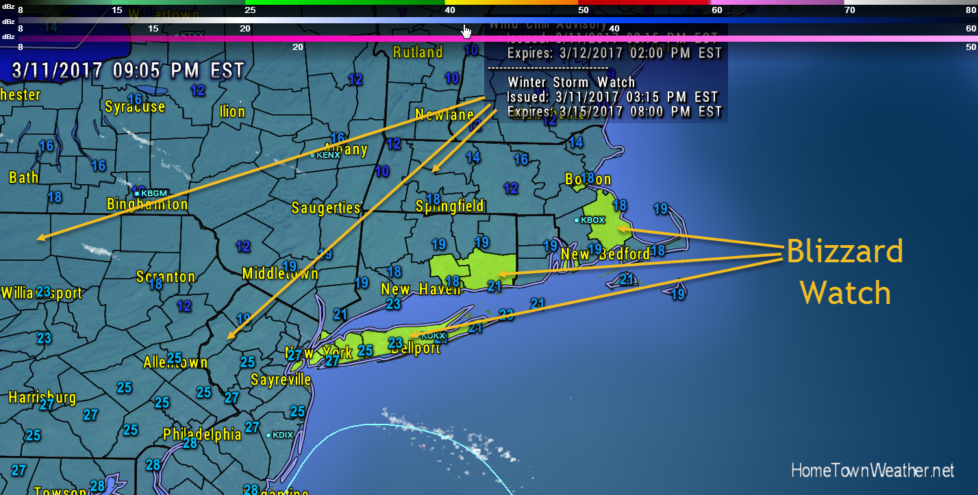
Tag Archive for new york
Blizzard Watch New York, Long Island, Eastern Massachusetts
Category: Weather Watch 2017 |
Tags: blizzard warning, boston, long island, new york, winter weather
Tropical Storm Joaquin Forms
***Now Tracking Tropical Storm Joaquin****
Depression 11 has strengthened to Tropical Storm Joaquin sooner then expected. Winds are now at 40 MPH with a cetral pressure of 1002 MB.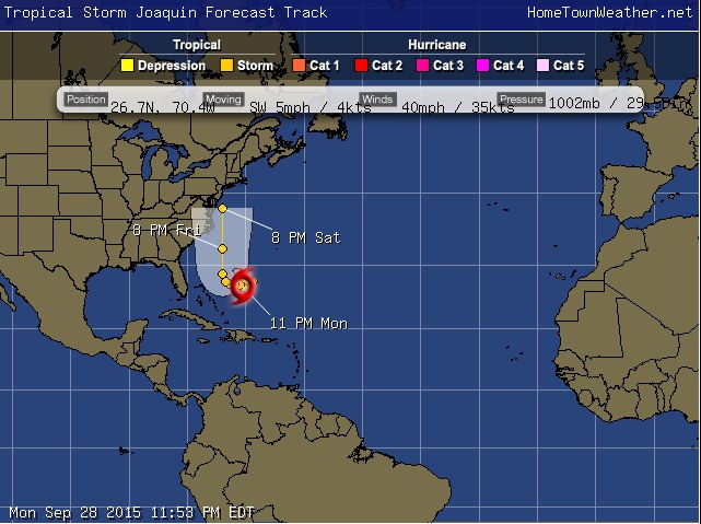
Satellite has shown that the cloud pattern has thunderstorm activity has increased and has gotten better organized over the past few hours.
The system is actually moving towards the southwest. The movement should then begin towards the west. This westward movement will likely continue for a couple of days. The system is being blocked by an upper level ridge.
Winter Storm Watch for New York/New Jersey
Winter Storm Watch for New York/New Jersey area.
URGENT – WINTER WEATHER MESSAGE
NATIONAL WEATHER SERVICE MOUNT HOLLY NJ
358 PM EST SAT JAN 31 2015
…A SIGNIFICANT WINTER STORM IS POSSIBLE FROM LATE SUNDAY INTO
MONDAY…
NJZ012-PAZ101-011000-
/O.EXA.KPHI.WS.A.0002.150202T0000Z-150202T1800Z/
MIDDLESEX-WESTERN CHESTER-
INCLUDING THE CITIES OF…NEW BRUNSWICK…HONEY BROOK…OXFORD
358 PM EST SAT JAN 31 2015
…WINTER STORM WATCH IN EFFECT FROM SUNDAY EVENING THROUGH
MONDAY AFTERNOON…
THE NATIONAL WEATHER SERVICE IN MOUNT HOLLY HAS ISSUED A WINTER
STORM WATCH. IT IS IN EFFECT FROM SUNDAY EVENING THROUGH MONDAY
AFTERNOON.
Winter Storm/Blizzard Of Historic Proportions Possible in NY/NJ and Mass.
**Winter Storm of Historic Proportions To Hit Mid Atlantic and New England on Monday night and Tuesday****
****DO NOT TRAVEL During this storm!!!!******
******Blizzard Conditions Possible!!!*****
A Winter storm watch has been issued for most of Massachusetts. A BLIZZARD Watch has been issued for Central Jersey including Middlesex county.
A major to historic storm is poised to hit the entire region. one to two feet of snow is possible in most locations. Locally heavier amounts are possible. Significant coastal flooding is possible as well.
Category: Winter Season 2015 |
Tags: blizzard watch, Massachusetts, New, New Jsery, new york, winter storm watch
New York/ Massachusetts Rain Event Wednesday Update
**New England/New York Rain**
Good morning everybody. The water vapor image looks like something out of October instead of summer. Lots of moisture is streaming in from the Atlantic and impressive amounts of rain are the result. There already has been 8-12 inches in Baltimore and over 5 inches in parts of NJ last night.
The intense rain band has already dropped over 10 inches in parts of western Long Island, as seen on the rainfall graphic. The rain will be slow to move east and with the tropical nature of the system, heavy rain will continue. Urban flooding will be the main threat.
Category: Weather Watch 2014 |
Tags: Flood Watch, floodwarning, long island flood, new england rain, new jersey, new york
Flood Watches for New England/New York/New Jersey on Wednesday
**Flood Watches for New England**
Good evening New England! Heavy rain will spread through the entire region late Tuesday through Wednesday. The rain chances are at 100% on Wednesday.The same goes for the New York/New Jersey area.
Flash flooding from the heavy rain will be possible. The NAM radar model I just ran shows the heavy precipitation moving through the entire region. This will be a widespread rain event.
There is also a probability of severe weather on Wednesday as well. The primary threat would be from high wind gusts but there is also a small probability of a brief tornado.
Potential Ice Storm Heading For New Jersey
The combination of low pressure developing in the Mississippi Valley and low pressure off the Carolina coast will be monitored through the night to be sure the forecast and development are on track. The potential for a significant ice storm event is possible.
For starters, the precipitation will start as snow in most locations. However, the track of the surface low will shortwave aloft will will result in good SW flow which will warm the upper levels of the atmosphere. This warming will change the precipitation to a sleet and freezing rain mix. The expectation is for moderate to heavy precipitation.