Archive for Winter Season 2015

Freeze Warnings for Treasure Coast in Florida

Freeze warnings are in effect for tonight! Wind chill advisories for tonight!!

Please protect your tender plants and get your pets inside tonight.

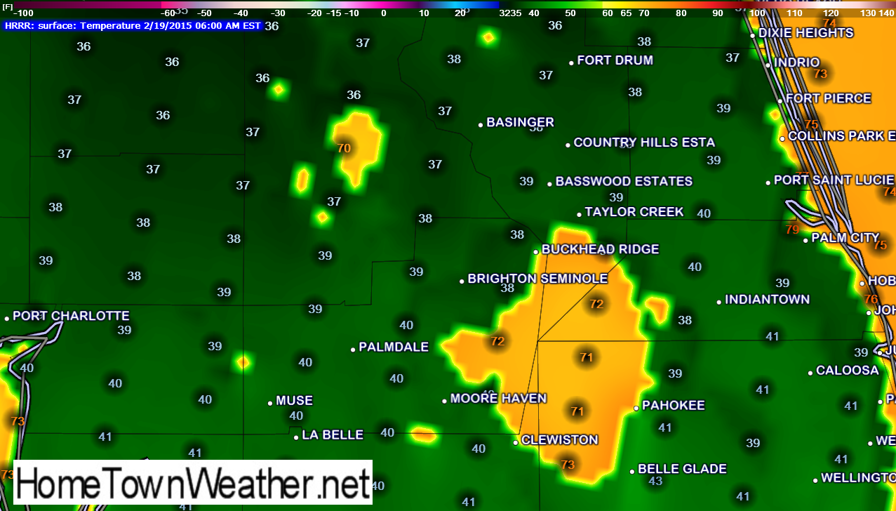
Temperatures are forecast to go to 31 degrees tonight in much of our area. It will even colder as you get towards Orlando.Some of our northern neighbors are under a hard freeze warning.

The models are still showing 33 degrees but there is not much difference if it is 31 or 33. It is still hovering right arond the freezing mark.This will be the coldest night in our area in quite some time.

Freeze Warnings for the Treasure Coast Tonight!!

**Freeze Warning……Lake Wind Advisory….Red Flag Warning********

LAKE WIND ADVISORY
Warning Issue Date: 1301 GMT FEB 19 2015
Warning Expiration: 600 PM EST THU FEB 19 2015

Freeze Warning Tonight!!

Good morning Treasure Coast!! It is a chilly morning across the region. The low at our weather station was 39 at 7:31 this morning. The official forecast and the models indicated that so the forecast was right on target. Today, it will struggle just to get past the 55 degree mark.

Treasure Coast Temperatures Bumped Up Tonight

Good late afternoon Treasure Coast!! The temperature forecast for tonight has been bumped up a bit and the HRRR temperature model verifies that. The original forecast called for 35 and now we are looking more at 39 or 40 and warmer right along the coast.
It will be interesting to see if the forecast for tomorrow night changes some as well in response to the model output.
Treasure Coast Radar and Forecast:
http://treasurecoastradar.com/


temp

Freeze Watch for the Treasure Coast in Florida (Friday AM)

Not sure at this point. Been running all the various temperature models and I am just not seeing freezing temperatures along the Treasure Coast. According to the models, the freezing temps are staying well inland and along the west coast of Florida. I keep coming up with 35 as a low. They are predicting 31 for our area as we are under a freeze watch for tomorrow night. I am now running the GFS model to see if there is any difference in the results. Even with this model I am seeing about 35 in our region. Areas farther north of the Treasure Coast are almost definitely going to see freezing temps.

Cold Front Approaching Florida

Good morning Treasure Coast!! As a good part of the East Coast wakes up to snow and ice, 70 degree temperatures are the rule for most of Florida this morning.

A low pressure area located over SE South Carolina is moving NE into the Atlantic. The trailing cold front is now located in North Florida. The front is accompanied by rain and a few thunderstorms. This rain shield will reach our area later this afternoon into tonight.

Snow Probability Charts for Days 1, 2 and 3

We just ran the Day 1, Day 2 and Day 3 snow probability chart. The areas in RED have the greatest chances for significant snowfall greater then 4 inches.
http://www.joesdiscoweathercentral.com/Weather_Models.html


snow1 snow2

Probability of Snow Model

The following graphic shows the probability that and area will get greater then 4 inches of the white stuff in the next 2 days. The RED outlined area is HIGH. The GREEN area is MODERATE and the BLUE area is SLIGHT.


snow

Winter Storm watch New Jersey..Includes Middlesex County

***Winter Storm Watch for parts of New Jersey including Middlesex County***

Dangerous cold followed by significant snow Monday night and Tuesday******
NATIONAL WEATHER SERVICE MOUNT HOLLY NJ
858 PM EST SUN FEB 15 2015

…DANGEROUS COLD FOLLOWED BY THE POTENTIAL FOR SIGNIFICANT
ACCUMULATING SNOW MONDAY NIGHT AND TUESDAY…

NJZ010-012-015-PAZ102-104-106-161000-
/O.CON.KPHI.WC.Y.0008.000000T0000Z-150216T1600Z/
/O.CON.KPHI.WS.A.0004.150216T2300Z-150217T1700Z/
SOMERSET-MIDDLESEX-MERCER-EASTERN CHESTER-EASTERN MONTGOMERY-
LOWER BUCKS-
INCLUDING THE CITIES OF…SOMERVILLE…NEW BRUNSWICK…TRENTON…
WEST CHESTER…KENNETT SQUARE…NORRISTOWN…LANSDALE…
MORRISVILLE…DOYLESTOWN
858 PM EST SUN FEB 15 2015

…WIND CHILL ADVISORY REMAINS IN EFFECT UNTIL 11 AM EST MONDAY…
…WINTER STORM WATCH REMAINS IN EFFECT FROM MONDAY EVENING
THROUGH TUESDAY MORNING…

Winter Storm Warning for Baltimore/Washington DC Area

***Winter Storm Warning….Baltimore/Washington DC Area****

NATIONAL WEATHER SERVICE BALTIMORE MD/WASHINGTON DC
953 PM EST SUN FEB 15 2015

DCZ001-MDZ013-014-016>018-504-506-VAZ054-161100-
/O.UPG.KLWX.WS.A.0003.150216T2300Z-150217T1700Z/
/O.NEW.KLWX.WS.W.0005.150216T2300Z-150217T1700Z/
/O.CON.KLWX.WC.Y.0008.000000T0000Z-150216T1500Z/
DISTRICT OF COLUMBIA-PRINCE GEORGES-ANNE ARUNDEL-CHARLES-
ST. MARYS-CALVERT-CENTRAL AND SOUTHEASTERN MONTGOMERY-
CENTRAL AND SOUTHEAST HOWARD-ARLINGTON/FALLS CHURCH/ALEXANDRIA-
INCLUDING THE CITIES OF…WASHINGTON…ANNAPOLIS…WALDORF…
ST MARYS CITY…ROCKVILLE…COLUMBIA…ELLICOTT CITY…
ALEXANDRIA…FALLS CHURCH
953 PM EST SUN FEB 15 2015

…WIND CHILL ADVISORY REMAINS IN EFFECT UNTIL 10 AM EST MONDAY…
…WINTER STORM WARNING IN EFFECT FROM 6 PM MONDAY TO NOON EST
TUESDAY…

Your Source for Treasure Coast, Florida Forecasts and Radar!Treasure Coast Forecast