
Good morning Treasure Coast. WE have a lot going on so let’s get to it. Of course our main concern is what is happening in the tropics. A hurricane hunter is going out today to investigate the system that I expect will soon be Colin. The model trends have been more towards North Florida but these models will likely change when the system develops. Regardless of the track, the system will be large and will affect a large area with rain and potential severe weather.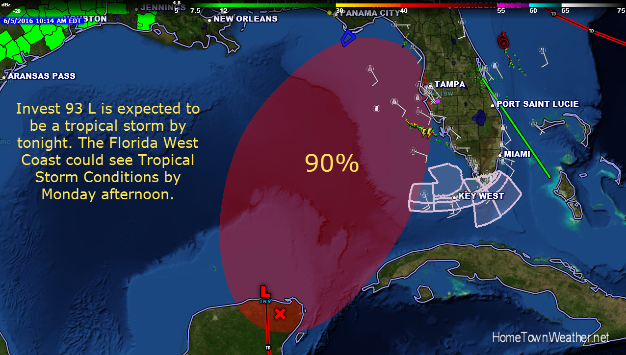
Tag Archive for Florida
Heavy Rain Event for East Central Florida
Potential Tropical Activity for Florida
Good evening everybody. We continue to closely monitor the potential development in the Gulf. System development is becoming more likely as time goes on. Regardless of system development, rain chances are going to increase significantly early next week in East Central Florida. Deep tropical moisture is going to bring increased rain chances to our region as well as most of Florida.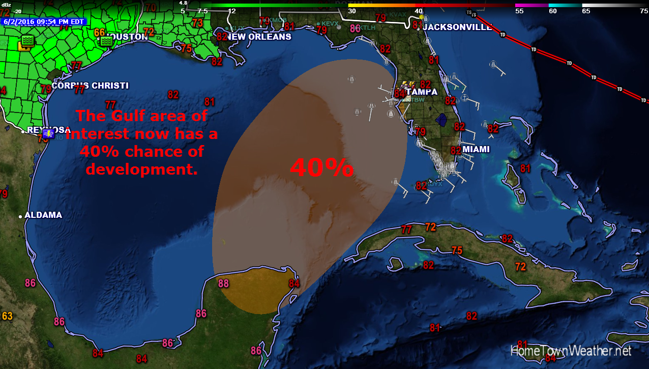
Significant Weather Advisory for Martin and St Lucie County in Florida
SPECIAL WEATHER STATEMENT
NATIONAL WEATHER SERVICE MELBOURNE FL
315 PM EDT FRI JUN 26 2015
FLZ059-064-262015-
MARTIN FL-ST. LUCIE FL-
315 PM EDT FRI JUN 26 2015
…SIGNIFICANT WEATHER ADVISORY FOR SOUTHEASTERN ST. LUCIE AND
EASTERN MARTIN COUNTIES UNTIL 415 PM EDT…
AT 314 PM EDT…DOPPLER RADAR WAS TRACKING A STRONG THUNDERSTORM
OVER MARTIN COUNTY NEAR PALM CITY…DRIFTING NORTH TOWARDS
SOUTHEASTERN SAINT LUCIE COUNTY AT 10 MPH.
DIME SIZE HAIL AND WIND GUSTS OF 50 TO 55 MPH WILL BE POSSIBLE WITH
THIS STORM.
Category: Weather Watch 2015 |
Tags: Florida, martin county, significant weather advisory, st. lucie county
Cold Front Moving Through Florida Tonight
The latest HRRR convection model run of the cold front moving through Florida tonight. Showers and a possible rumble of thunder are possible.
Cold Front Approaching Florida
Good morning Treasure Coast!! As a good part of the East Coast wakes up to snow and ice, 70 degree temperatures are the rule for most of Florida this morning.
A low pressure area located over SE South Carolina is moving NE into the Atlantic. The trailing cold front is now located in North Florida. The front is accompanied by rain and a few thunderstorms. This rain shield will reach our area later this afternoon into tonight.
Strong Cold Front To Move Through Florida
Good Monday morning Treasure Coast!! Although we are not in a tornado watch area, a line of rain and storms will likely move across our region ahead of a strong cold front. Tornado watches are in place for parts of the Florida Panhandle at this hour.
Today, a strong cold front will approach East Central Florida and will move through the area by late tonight. We could see some lightning storms develop ahead of this frontal system along with heavy rain and wind gusts to 50 MPH.
Hurricane Wilma 9 Year Anniversary
Nine years ago Friday on October 24, 2005, Hurricane Wilma blasted through Florida with strong winds and rain causing widespread power outages throughout most of Florida. Wilma was the last big storm to make landfall in Florida. 2005 was also the year that Katrina devastated the Gulf states. Wilma at one point in time had the lowest recorded pressure ever recorded in the Atlantic.
Tornado Watches Issued From Orlando, Florida South
URGENT – IMMEDIATE BROADCAST REQUESTED
TORNADO WATCH NUMBER 27
NWS STORM PREDICTION CENTER NORMAN OK
1125 AM EST THU MAR 6 2014
THE NWS STORM PREDICTION CENTER HAS ISSUED A
* TORNADO WATCH FOR PORTIONS OF
THE CENTRAL AND SOUTHERN FLORIDA PENINSULA
COASTAL WATERS
* EFFECTIVE THIS THURSDAY MORNING AND EVENING FROM 1125 AM UNTIL
700 PM EST.
* PRIMARY THREATS INCLUDE…
SEVERAL TORNADOES POSSIBLE
SEVERAL DAMAGING WIND GUSTS TO 70 MPH LIKELY
SEVERAL LARGE HAIL EVENTS TO 1 INCH IN DIAMETER POSSIBLE
Radar Model Forecasts for Florida Precipitation
Simulated radar over the next 2 days. The first frame shows the front approaching around 4 PM tomorrow. The second frame represents the radar around 6 PM tomorrow. The third frame represents around 8 PM tomorrow night and the final frame shows around 10 tomorrow night. You can see by the model the precipitation overspreads most of the area around 8 PM. This is not a forecast, it is a model run and great differences in the precipitation and/or timing could be realized.
For Real time radar loops for Florida:
http://www.joesdiscoweathercentral.com/Florida_Doppler_radar_Loops.html
Category: Weather Watch 2014 |
Tags: Florida