
Archive for joesdiscoweathercentral
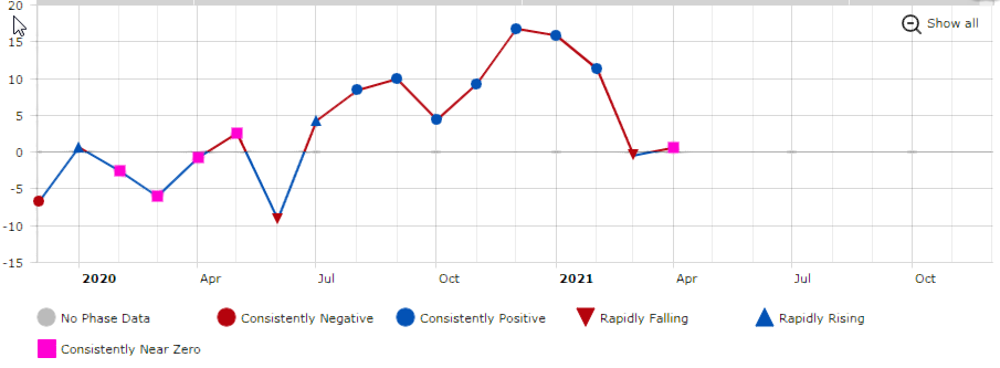
Monthly Graph of The ENSO From 2020 and 2021
This is a monthly graph of the ENSO from 2020 through 2021. Negative is trending towards El Nino and Positive is trending towards La Nina. Near 0 means Neutral. that is right where we are right now. You can clearly see the positive trend during the peak of the hurricane season last year (La Nina). Right now we are near neutral and the new models expect us to stay that way through the peak of hurricane season. Still points to an active season, but nothing like last year.
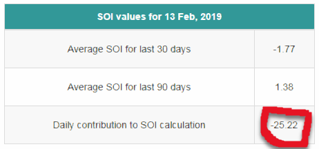
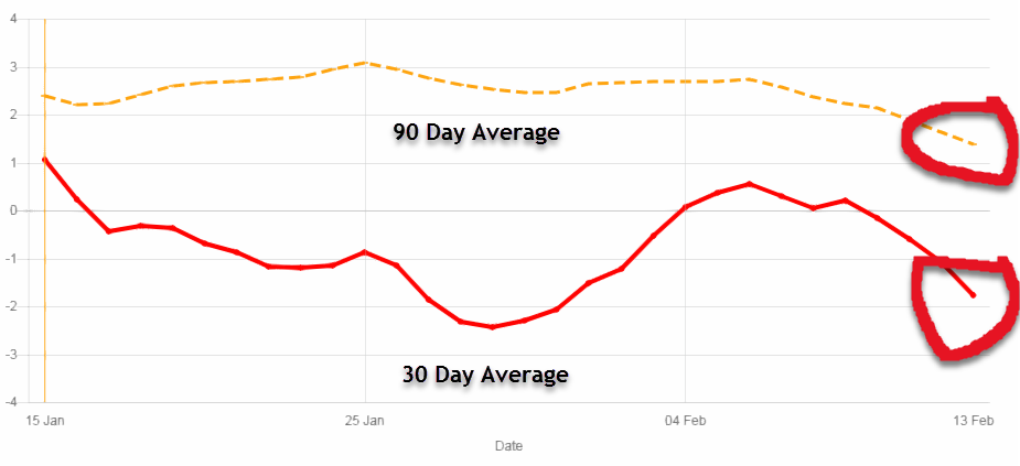
The SOI (Southern Oscillation Index ) is a huge barometer as to how busy a hurricane season might be. Essentially, this is how warm or cold the Pacific waters are in the tropical ENSO regions. The SOI is calculated from the difference in pressure between Darwin and Tahiti. These pressure differences control what direction the trade winds blow in the tropical Pacific. The direction of these trade winds help determine how warm or cold those waters will be.
Like
Comment
NOAA Predicts Above Average Season for 2021
NOAA has released their 2021 Hurricane forecast for 2021. They are predicting 13 to 20 named storms with 6 to 10 becomming Hurricanes and 3 to 5 becomming major hurricanes of category 3 or higher.
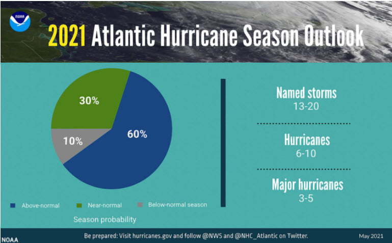
Although the 2021 hurricane season is NOT expected to be as bad as the 2020 season, it is expected to be above normal. There was a lot of talk about what areas the hurricanes could hit, it was plainly noted that impact areas cannot be predicted until a storm is about a week out. Early predictions of impact areas is simply not accurate. NOAA has also stated that they have new technologies that they will be using this season such as drones that will be released into the storms and on the ocean surface for a better understanding of what is going on inside the storm. This information will be put into the models to allow for more accurate forecasts.
Category: Hurricane Season 2021 |
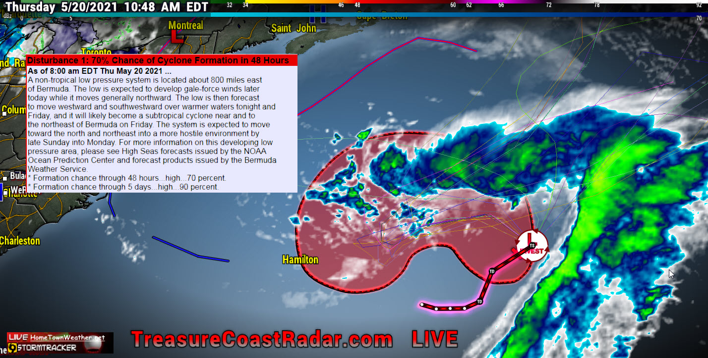
Non-Tropical Disturbance Has 90% Chance Of Development. No Threat.
Good Thursday morning everybody! The low pressure area in the Central Atlantic now has a 90% chance of development. It will not pose a threat to the United States.
Category: Hurricane Season 2021 |
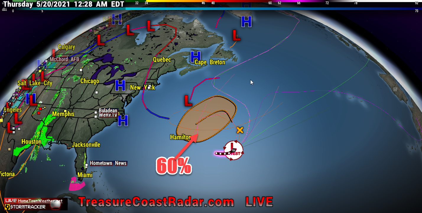
Invest Has 60% Chance Of Development
Even though this area has a 60% chance of formation, It will not affect the US. This is just a simple reminder that the season is almost upon us. We will be here for you without the HYPE and ANXIETY and just the facts as we have been for the past 24 years. Our website was one of the first third party websites in existence in the day. Today, most people either use apps or Facebook for getting their information. Our website is still there although a bit smaller, for those that still get their information on a computer. For fastest updates, Facebook is the way to go. We hope everybody fares well this Hurricane Season. Remember that preparation is key.
We do supply models out to about 7 days for those that like to view them. Remember that models are not forecasts and they can and likely will change. They are an important part of looking into the future. Models out past 7 days are quite useless and we rarely will show them.
We will hope and pray that the 2021 Hurricane Season spares as many as possible the extreme damage that we have seen over the years. Simply be prepared and ready for the worst and hope for the best.
Category: Uncategorized |
Watching Two Areas In The Atlantic
7/30/19 Tuesday- Today we are watching 2 areas in the Atlantic. Invest 95L in the Caribbean and an area of disturbed weather in the Eastern Atlantic. Right now Invest 95L has a 10% (low) chance of development. Regardless of development, it will mainly be an increase in rain chances for Florida and possibly also along the East Coast. Wind shear, dust and interaction with land will keep this system from developing in the short term. If any development does occur it will likely be weak and not until it is East of Florida or the Carolina’s.
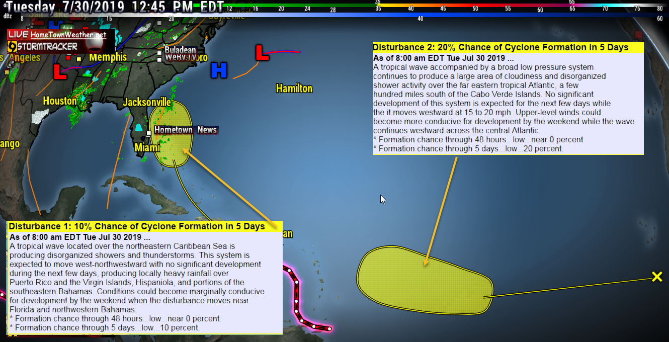
Category: Tropic Watch 2019, Uncategorized |
Cape Cod Massachusetts Tornado 7/23/19
Today a rare tornado outbreak occurred in Cape Cod Massachusetts. In addition to the tornado were straight line wind bursts that did extensive damage especially in the town of Harwich. Nearly 600,000 people were without power. this event unfolded as a rare July cold front was passing through the region. Although the cold front broke the extreme heat wave, it came with a cost. Below is the Public Information statement that was issued as well as the list of Storm Damage Reports.
Category: 2019 Massachusetts Tornado. |
SOI (Southern Oscillation Index) Takes A Dive
Good Wednesday all. Looking at today’s SOI index, it has taken a nose dive. What this means is that if the trend continues, Westerly trade winds will develop in the Pacific that will usher in warmer water to the ENSO regions. This is how an El Nino gets started. Will it happen? Nobody can predict it accurately, not even the models.
Category: SOI (Southern Oscillation Index |
Tags: atlantic, hurricane season, Pacific, Sea Surface Temperatures, SOI, Southern Oscillation Index, SST
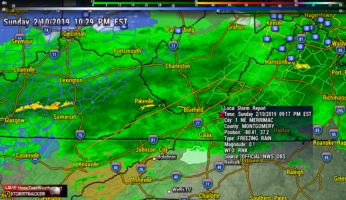
Freezing Rain Reported Merrimac, Virginia
…Winter Weather Advisories in effect tonight…
A mixture of rain, freezing rain, and sleet will continue across
the area tonight. Ice accumulations up to a tenth of an inch is
possible in the coldest locations. Icy roads have been reported on
Potts Mountain along Route 311. Drivers should prepare for
slippery icy roadways and use extra caution while driving
tonight. Freezing Rain.
Category: Uncategorized |
Live Treasure Coast, Florida, Radar
This is our LIVE feed from Melbourne, Florida of our Treasure Coast Radar.