
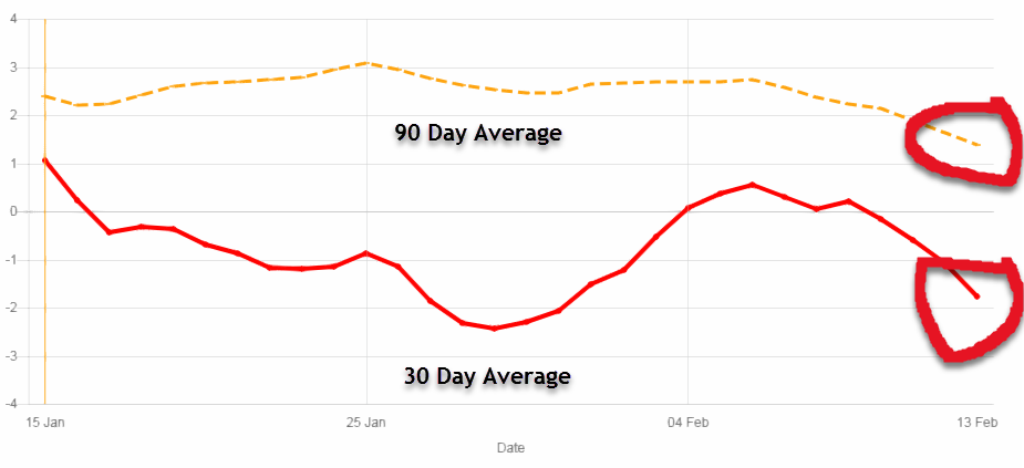
Monthly Graph of The ENSO From 2020 and 2021
This is a monthly graph of the ENSO from 2020 through 2021. Negative is trending towards El Nino and Positive is trending towards La Nina. Near 0 means Neutral. that is right where we are right now. You can clearly see the positive trend during the peak of the hurricane season last year (La Nina). Right now we are near neutral and the new models expect us to stay that way through the peak of hurricane season. Still points to an active season, but nothing like last year.
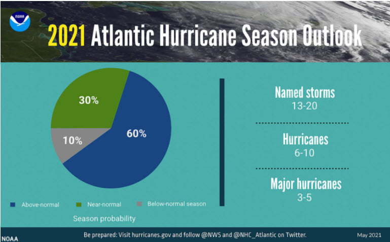
NOAA Predicts Above Average Season for 2021
NOAA has released their 2021 Hurricane forecast for 2021. They are predicting 13 to 20 named storms with 6 to 10 becomming Hurricanes and 3 to 5 becomming major hurricanes of category 3 or higher.
Category: Hurricane Season 2021 |
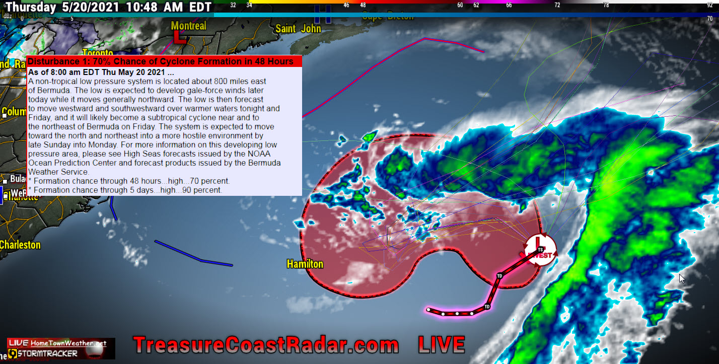
Non-Tropical Disturbance Has 90% Chance Of Development. No Threat.
Good Thursday morning everybody! The low pressure area in the Central Atlantic now has a 90% chance of development. It will not pose a threat to the United States.
Category: Hurricane Season 2021 |
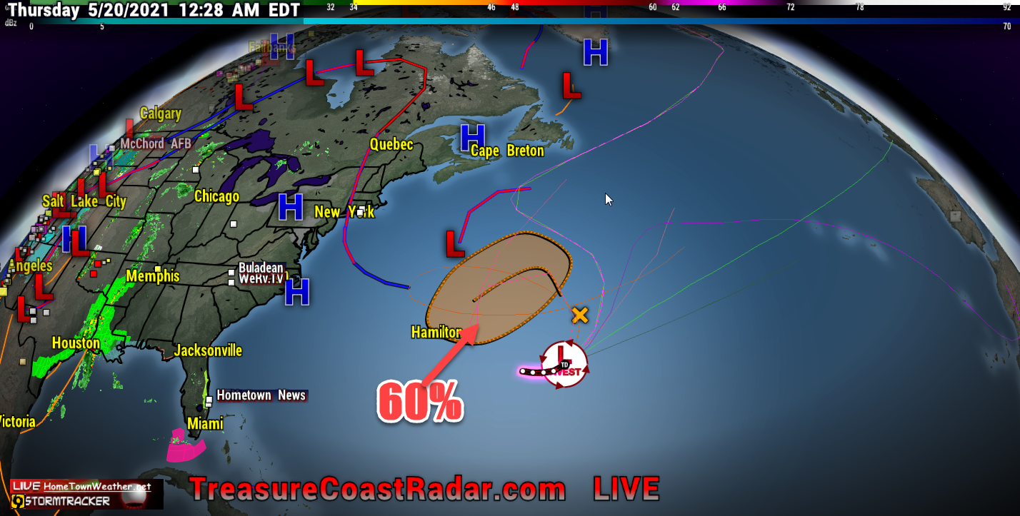
Invest Has 60% Chance Of Development
Even though this area has a 60% chance of formation, It will not affect the US. This is just a simple reminder that the season is almost upon us. We will be here for you without the HYPE and ANXIETY and just the facts as we have been for the past 24 years. Our website was one of the first third party websites in existence in the day. Today, most people either use apps or Facebook for getting their information. Our website is still there although a bit smaller, for those that still get their information on a computer. For fastest updates, Facebook is the way to go. We hope everybody fares well this Hurricane Season. Remember that preparation is key.
We do supply models out to about 7 days for those that like to view them. Remember that models are not forecasts and they can and likely will change. They are an important part of looking into the future. Models out past 7 days are quite useless and we rarely will show them.
We will hope and pray that the 2021 Hurricane Season spares as many as possible the extreme damage that we have seen over the years. Simply be prepared and ready for the worst and hope for the best.
Category: Uncategorized |
Watching Two Areas In The Atlantic
7/30/19 Tuesday- Today we are watching 2 areas in the Atlantic. Invest 95L in the Caribbean and an area of disturbed weather in the Eastern Atlantic. Right now Invest 95L has a 10% (low) chance of development. Regardless of development, it will mainly be an increase in rain chances for Florida and possibly also along the East Coast. Wind shear, dust and interaction with land will keep this system from developing in the short term. If any development does occur it will likely be weak and not until it is East of Florida or the Carolina’s.
Category: Tropic Watch 2019, Uncategorized |
Cape Cod Massachusetts Tornado 7/23/19
Today a rare tornado outbreak occurred in Cape Cod Massachusetts. In addition to the tornado were straight line wind bursts that did extensive damage especially in the town of Harwich. Nearly 600,000 people were without power. this event unfolded as a rare July cold front was passing through the region. Although the cold front broke the extreme heat wave, it came with a cost. Below is the Public Information statement that was issued as well as the list of Storm Damage Reports.
Category: 2019 Massachusetts Tornado. |
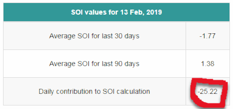
SOI (Southern Oscillation Index) Takes A Dive
Good Wednesday all. Looking at today’s SOI index, it has taken a nose dive. What this means is that if the trend continues, Westerly trade winds will develop in the Pacific that will usher in warmer water to the ENSO regions. This is how an El Nino gets started. Will it happen? Nobody can predict it accurately, not even the models.
Category: SOI (Southern Oscillation Index |
Tags: atlantic, hurricane season, Pacific, Sea Surface Temperatures, SOI, Southern Oscillation Index, SST
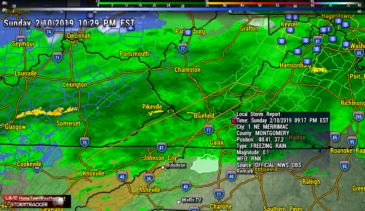
Freezing Rain Reported Merrimac, Virginia
…Winter Weather Advisories in effect tonight…
A mixture of rain, freezing rain, and sleet will continue across
the area tonight. Ice accumulations up to a tenth of an inch is
possible in the coldest locations. Icy roads have been reported on
Potts Mountain along Route 311. Drivers should prepare for
slippery icy roadways and use extra caution while driving
tonight. Freezing Rain.
Category: Uncategorized |
Live Treasure Coast, Florida, Radar
This is our LIVE feed from Melbourne, Florida of our Treasure Coast Radar.
Hurricane Florence, My Final Thoughts
I have been a storm spotter/tracker since 1997 and I have seen, experienced and tracked some of the worst scenarios known to man. Hurricanes are by far the most destructive storms on the face of the planet. I have had personal experiences with more hurricanes then I care to remember. As destructive as they are, hurricanes are an important part of our eco-system. They are necessary to balance out the heat from the deep tropics and transfer some of that heat to the northern latitudes. Without this heat equalization, our climate could suffer even bigger consequences. Normally, hurricanes want to recurve out to sea, The rotation tries its best but sometimes big bubbles of air (High Pressure) get in the way and totally disrupt this process. That was the case with Florence. The position that Florence was located in the ocean has never in History produced a storm that made landfall. Most storms that affect the Carolinas come in more from a southerly angle through the Bahamas or just East of the Bahamas. The angle of approach for Florence was unprecedented.
NOAA Increases The Chance For Below Normal Hurricane Season
As we sail towards the peak of the Atlantic Hurricane Season, the forecasters at NOAA have decreased both the chances of a bad season and the total number of expected storms. In May, there was only a 25% chance of a below normal season. As of August 9, that chance has increased to 60%. The chances of an above normal season has dropped to only 10%.
Remembering Hurricane Irma 2017
Not a day goes by where somebody in Florida or the Islands of the Caribbean remembers the day Hurricane Irma paid a visit in September of 2017. In that year, all the signs of an extreme hurricane season where there. SST temperatures were at their highest, the wind shear in the Atlantic and Caribbean was low and the Bermuda high was in the perfect position for a US landfall. All the ingredients were in place.
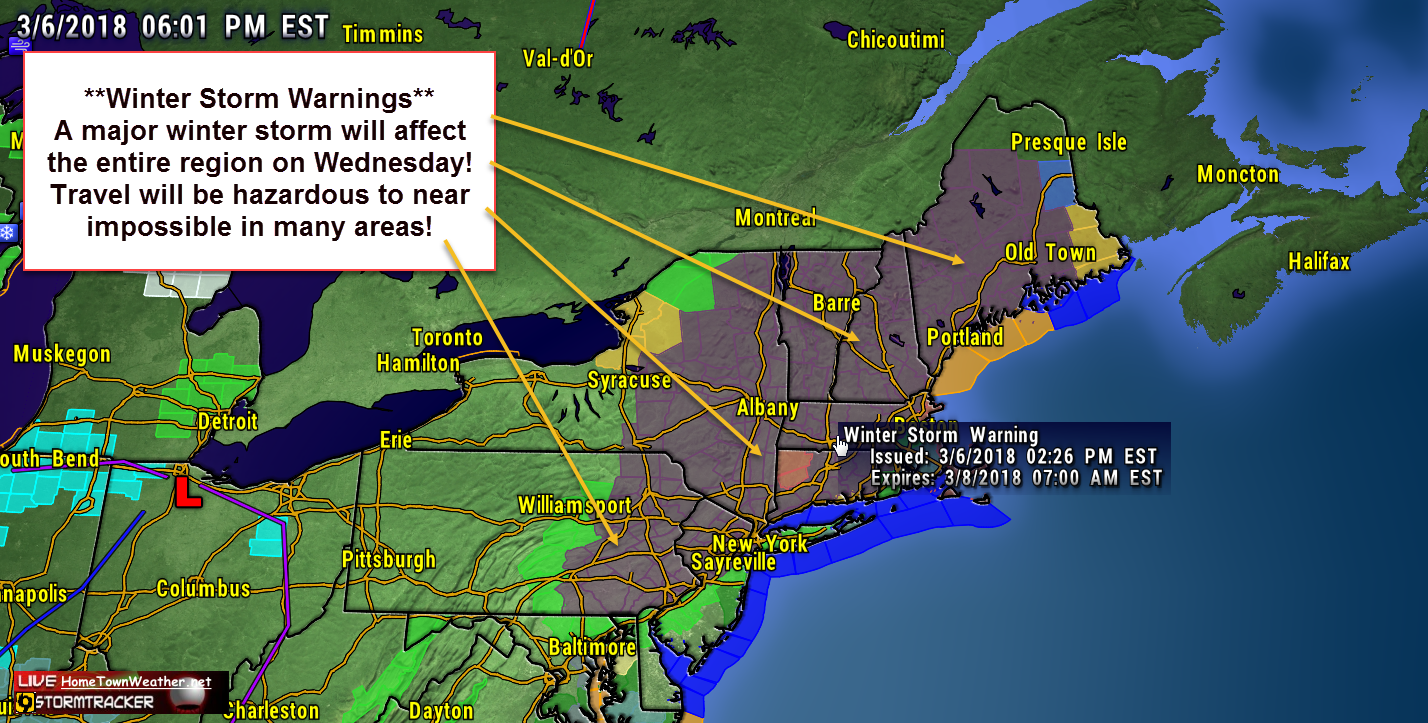
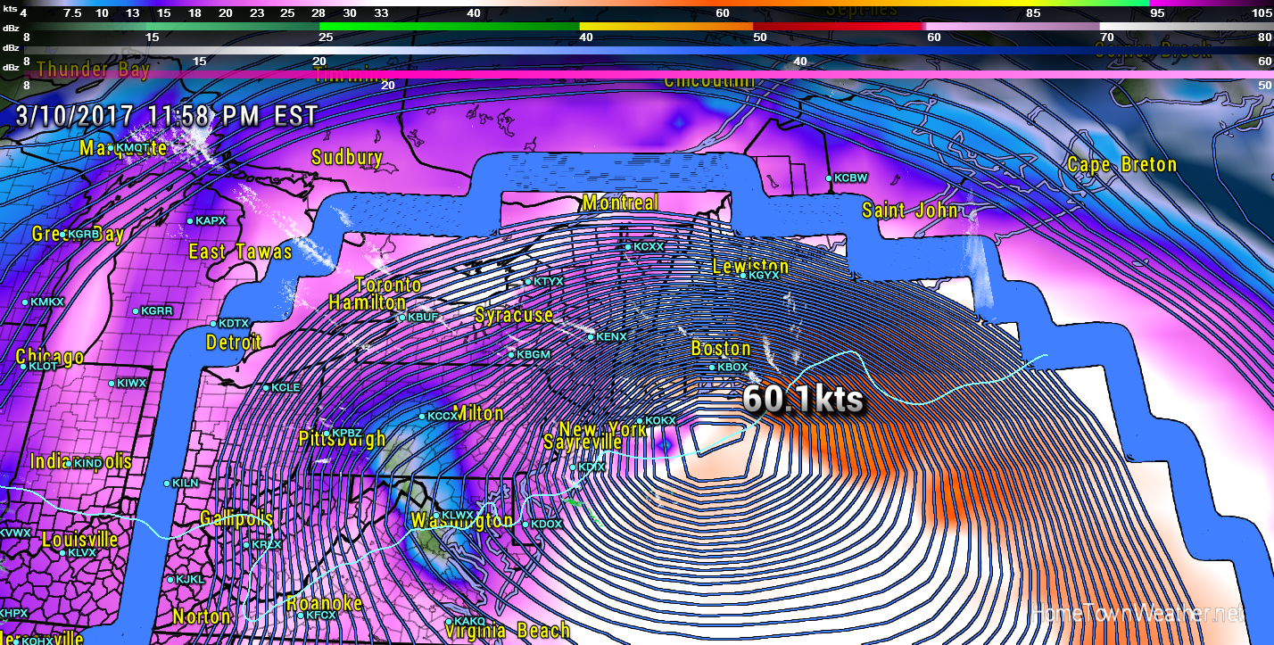
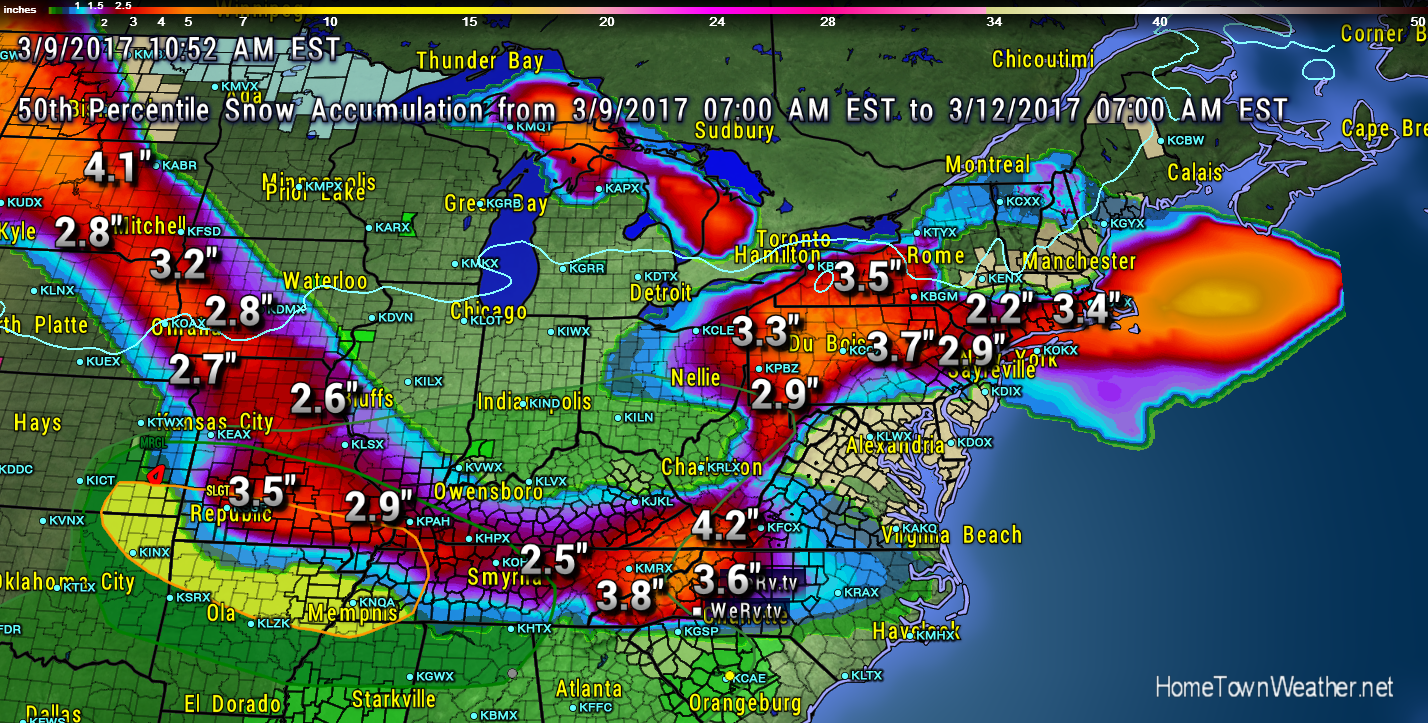
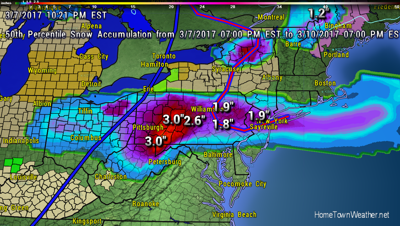
Major Nor’ Easter Headed For North East
Another week, another Nor’Easter. It is starting to be a weekly routine in the Mid Atlantic and New England. A surface low will develop off the Delmarva Peninsula tonight and will drift northward as it develops. There is more confidence that the track will be closer to the coast and the result will be more precipitation, mostly in the form of snow. As a result, Winter Storm Warnings have been issued for a good part of the region.
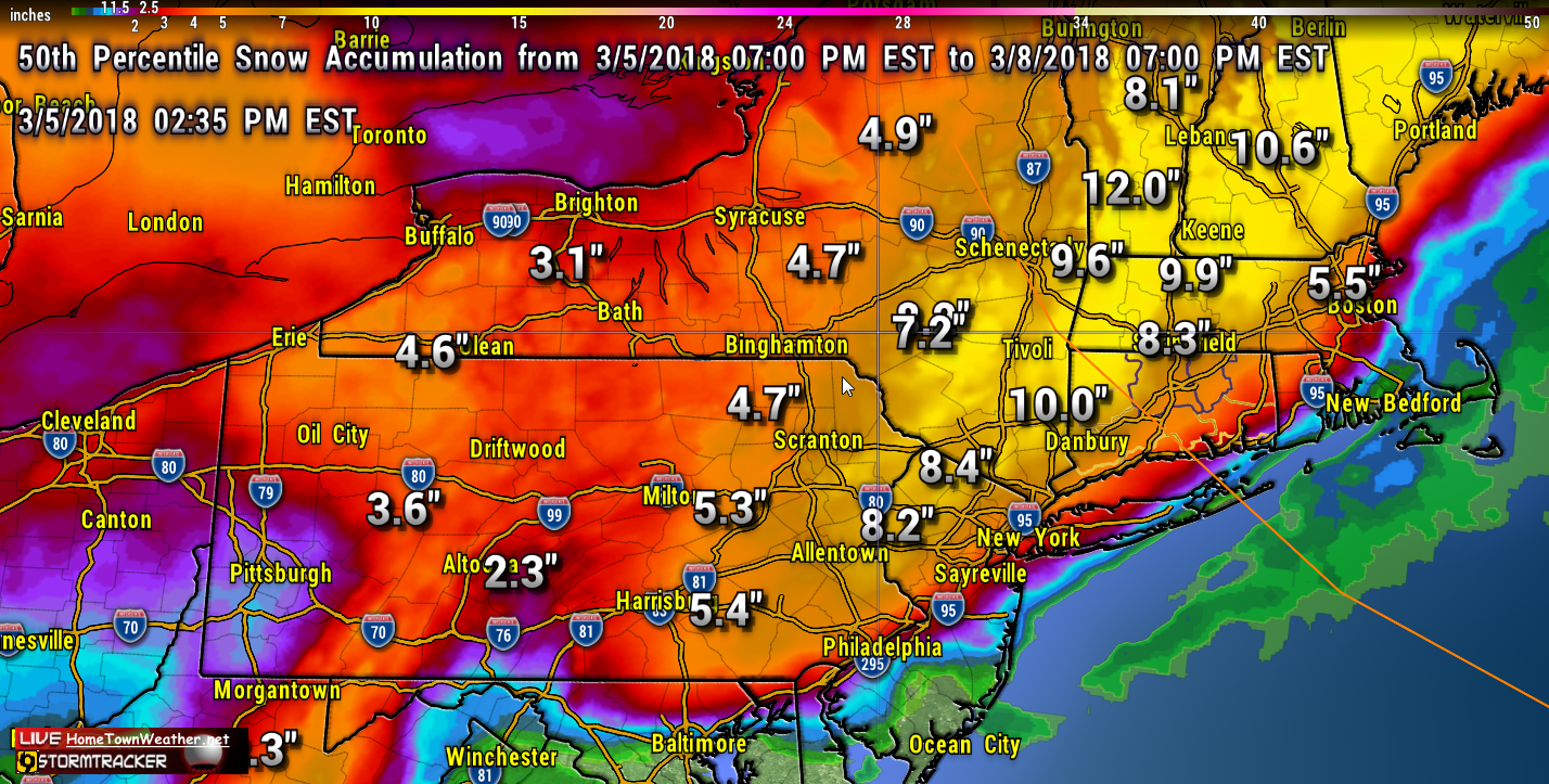
Another Nor’Easter Threatens the North East
With the threat increasing for another Nor’Easter this Wednesday and Thursday in New England, folks should be getting ready for another round of power outages. In some cases, there are still people that have not got their power back from the last storm. it is possible that some part of the North East could have blizzard warnings. The following snow model shows some decent plowable snow coming to most areas.
Second Round of Storms Possible for North East!
As if the latest super storm was not enough, yet another round of potential severe weather is possible about mid week in the north east. Models are again suggesting a developing low pressure area moving up the coast and creating a wind, coastal flood and snow event.
Although not near as bad, it will be affecting many of the same areas that were just hit hard by Riley. In many cases, recovery is only beginning.
Potential New Years Eve Storm Possible
Many parts of the North East have been treated to a White Christmas this year but what about New Years? There remains the potential for a Nor’Easter to form off or on the East Coast this New Years Eve but a couple of things will have to happen in order for this scenario to take place.

The GFS shows the center of the system offshore but this could change and a storm could track either closer to the coast or farther offshore.
14 Days Till Hurricane Season 2017 Begins | Are You prepared?
It is hard to believe that Hurricane Season 2017 is almost here. Since the last hurricane seasonal projection, lots of things have changed to make almost a complete 360. Now it does not look as likely that El Nino will be strong enough to affect the peak of the 20017 season. In addition, the water temperatures have rapidly started to warm up.
Category: Tropic Watch 2017 |
Tags: hurricane season, hurricane season 2017, tropical, tropical prediction
Treasure Coast | April 29, 2017 Forecast | Florida |
Good Saturday morning Treasure Coast! Very dry air exists along the Treasure Coast today. A few showers near the immediate coast is possible later today into tonight.
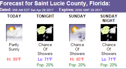
The high today will be around 90 with very low rain chances. Saturday night looks pleasant with lows around 70. Sunday, the shower chances are up just a bit to 20%. The high on Sunday will be in the mid 80’s. As we migrate to next week, the rain chances are bumped up to 40% on Tuesday and Friday.
Hurricane Season 2017 Outlook
Its that time again when we are looking towards the beginning of Hurricane Season 2017. Last year was predicted to be an above average season and it lived up to its name. This was especially true when Hurricane Matthew churned up the East Coast of Florida and came within 35 miles of the coast. A few miles to the west would of made all the difference in the world. The strongest winds stayed just a few miles offshore the coast. It was a wake up call for the residents of the East Coast of Florida that hopefully will not be soon forgotten.
Blizzard Watch New York, Long Island, Eastern Massachusetts
A major winter storm is forecast to affect the North East from late Monday through Tuesday night. Blizzard watches have been issued for metro areas such as New York City and Boston as well as Long Island. Winter storm watches have been issued for almost all of the North East. 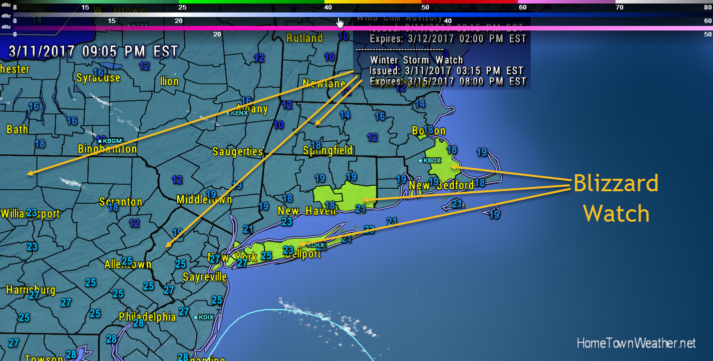
Category: Weather Watch 2017 |
Tags: blizzard warning, boston, long island, new york, winter weather
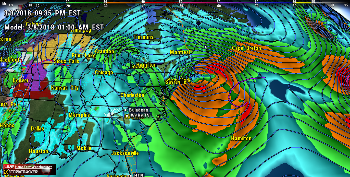
Potential North East Nor’Easter | Heavy Snow | Coastal Flooding
The potential for a major storm (Nor’Easter) to hit the Mid Atlantic and/or New England early next week is getting more likely. The latest GFS model shows a potent storm just off the New England coast on Tuesday. Note how close the isobars are clustered together as the system wraps up.
North Carolina Snow | Potential East Coast Nor’ Easter
Even though it is already March, and Daylight Savings Time is almost here, Old Man Winter is coming back with a vengeance this week. A series of snow storms will affect the high country of North Carolina and even parts of Virginia this weekend and early next week. Winter Weather Advisories and Winter Storm Warnings are in effect the region.
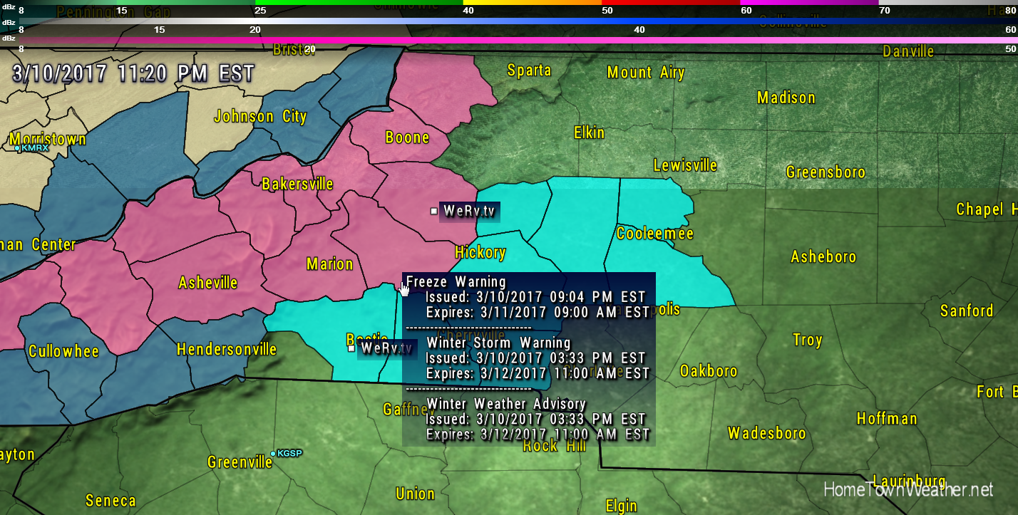
Category: Winter Weather 2017 |
Hurricane Season | Names and Changes for 2017
Hurricane season is still almost 3 months away but we Storm Spotters are already looking ahead at the 2017 season. This year there will be some changes to the products that are delivered by the NHC. This year the storm surge maps that have been experimental will go live. This tool will be a lifesaver for sure. It will give you up to the minute information of what areas will be affected by deadly storm surge. Remember that most hurricane deaths are not caused by winds but rather from drowning in waters created by the hurricanes storm surge.
Weather | Snow For the Mid Atlantic and South
Good morning everybody. Snow will be the topic of the day as it threatens to hit both parts of the Mid Atlantic and Southern New England as well as parts of the South including a portion of North Carolina. A Winter Weather Watch is up for parts of Eastern New England.
Category: Weather Watch 2017 |
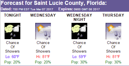
Treasure Coast | Forecast for March 8, 2017 | Florida Radar
Good Wednesday evening Treasure Coast. Warm weather will persist through the weekend but a slight cool down will bring some relief on Wednesday. The rain chances on Thursday will be 30%. Friday will be great with almost no rain chances and a high near 81.
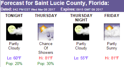
Thursday…Partly cloudy. Patchy fog towards morning. A slight chance of showers through late morning. A chance of afternoon showers. Highs in the lower 80s. West winds around 5 mph becoming east 5 to 10 mph in the afternoon. Chance of rain 30 percent.
Category: Treasure Coast Weather |
Weather | 3 Bouts of Snow Possible in Mid Atlantic
Weak low pressure will remain over the New York/New Jersey area through Thursday. A low pressure area will then develop off the Mid Atlantic coast and will bring an extreme change back to wintry conditions for the later part of the week. Snow will develop Thursday night into Friday.Much colder conditions will exist as Arctic High Pressure builds from Canada. The chart below shows the 72 hour projected snow totals.

Category: Weather Watch 2017 |
Weather | Snow Possible in Mid Atlantic
Good morning everybody! After several bouts of above normal temperatures, Winter is about to return again with the possibility of some snow in the Mid Atlantic or possibly even New England.

There will be several opportunities for this to happen. One will be around Friday, The second will be on Sunday and the third will be early next week. We will have to carefully watch the models to see where and how much snow might fall. The chart above shows the latest amounts forecast over the next 72 hours.
Category: Weather Watch 2017 |
Weather | Line Of Storms Moving Through The South
Showers and thunderstorms are moving through parts of the South East tonight bringing rain to the region. The area of showers extends from the Mid Atlantic all the way south through Louisiana and extending into the Gulf. the area of precipitation precedes a frontal system that is moving east through the Eastern part of the US.
The rain area will be moving towards the Florida Panhandle and the coastal areas of the Carolina’s and Georgia increasing the rain chances for Wednesday.
Category: Weather Watch 2017 |
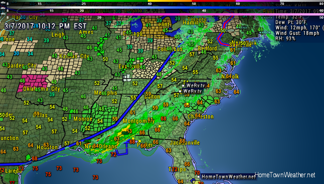
Treasure Coast Forecast, Wednesday 3/7/17
Good evening Treasure Coast!! We are heading into a gradual warming trend over the next few days as we approach the weekend. In fact by Saturday we are looking at temperatures near 85 degrees. There is about a 20% chance of a passing shower.
The Treasure Coast will be enjoying lots of sunshine while our friends to the north will be looking at the possibility of a snow storm this weekend. Remember to change your clocks forward one hour (Spring Ahead) on Saturday night before going to sleep.
Category: Treasure Coast Weather |
My Take on Matthew
Matthew is likely not a name you will want to hear for a long time. This was one of the most unusual storms that I have seen in all my years of tracking. It all began on September 25 when Invest 97 was born in the Atlantic. From that day forward, the models kept showing Matthew passing very close to the state of Florida. On September 28, Matthew became a named storm. On September 30, Matthew became a category 5 hurricane taking aim at Jamaica, Cuba and Haiti.
Invest 99 Was The Storm That Couldn’t
Invest 99 was the little engine that couldn’t. From the first day that we started tracking it, it appeared to struggle for survival. That said, a good part of forecasting a tropical systems track is in the computer generated models. These models in the early stages of a system often create a windshield wiper effect where they keep bouncing back and forth between two points. usually, the final result is someplace in between all the runs. A lot of this information is obtained by NOAA planes risking their lives flying into the storms. The information from these planes is invaluable. Even with all the computer models, manual observations, satellites and radar, sometimes systems do what they want and when they want. In the case of 99L, since it was so weak the models had a rough time trying to find a starting point. The two main models the GFS and the Euro were battling it out to see who could win. In almost every run, our own GFS seems to have had the solution all along but it was discounted because nobody thought it made any sense. Most of the other models were saying we were going to get slammed. Forecasters are often put in a position of either alerting the public of a potential threat or saying everything is going to be fine. When the vast majority of models say everything is not going to be fine, you have to listen to the majority.
The 2004 Hurricane Nightmare Began 13 Years Ago Today
Good morning Treasure Coast!! 12 years ago today, the hurricane nightmare of 2004 began. First we had Hurricane Charley that came ashore the West Coast of Florida. That storm lasted from August 9-15. Then came Hurricane Frances that was born August 23 and lasted through September 6. Frances was not particularly strong but the system hovered over the Treasure Coast for hours pounding the area with sustained winds and flooding rain. Ivan was the next system to hit Florida and that system hit the Panhandle area with flooding rains and strong winds. Last but least is the infamous Hurricane Jeanne. Jeanne came ashore at almost the exact same place as Frances after doing a complete loop in the Atlantic. Jeanne lasted from September 13 through the 27th. Jeanne reinforced an already damaged Florida with even more damage. Because of these back to back hurricanes, most Treasure Coast homes now have newer roofs.
Category: Tropic Watch 2016 |
Tags: hurricane charley, hurricane frances, hurricane ivan, hurricane jeanne, hurricane season update
Hurricane Season 2016 Winding Up
Hurricane season 2016 is beginning to wind up and the parade of storms is starting to line up across the toasty Atlantic. It is so hard to ponder that it has been 11 years since we have a hurricane make landfall along the US East Coast. This is without doubt one of the longest hurricane draughts we have seen in recent history. The big question is if it will continue through 2016.
Category: Invest 96 and 97, Tropic Watch 2016 |
Tags: hurricane, invest 96, Invest 97, Tropical Storm
Heavy Rain Event for East Central Florida
Good morning Treasure Coast. WE have a lot going on so let’s get to it. Of course our main concern is what is happening in the tropics. A hurricane hunter is going out today to investigate the system that I expect will soon be Colin. The model trends have been more towards North Florida but these models will likely change when the system develops. Regardless of the track, the system will be large and will affect a large area with rain and potential severe weather.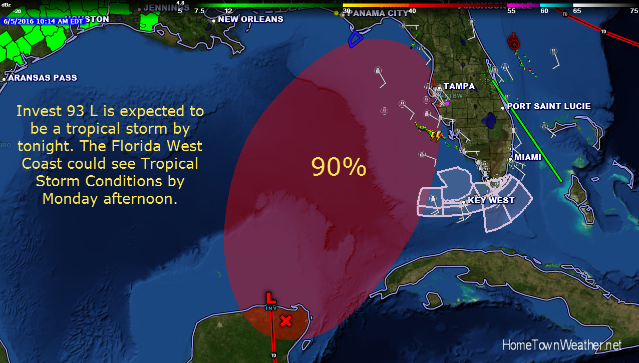
Potential Tropical Activity for Florida
Good evening everybody. We continue to closely monitor the potential development in the Gulf. System development is becoming more likely as time goes on. Regardless of system development, rain chances are going to increase significantly early next week in East Central Florida. Deep tropical moisture is going to bring increased rain chances to our region as well as most of Florida.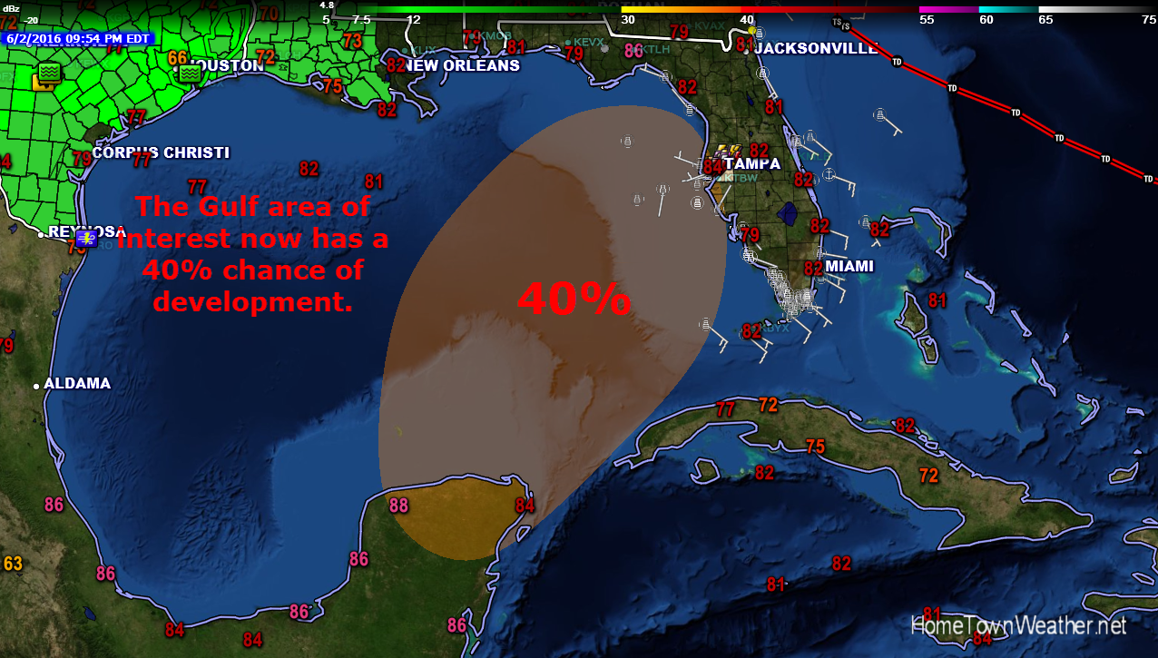
Hurricane Season 2016 Begins Today
Good Morning everybody and welcome to hurricane season 2016!! Today marks the first day of the Atlantic hurricane season. This year we area starting off the season with 2 storms already under our belt. In fact, some global models are showing the potential to a tropical entity early next week. I would not bank a whole lot on the hype since right now the Gulf of Mexico is completely clear and a forecast that far out is simply way too much speculation.
Hurricane Season Forecast Issued By Colorado State
The official hurricane season forecast is out from the Colorado State University. They are calling for an average season with 12 named storms. The new forecast is based on several factors including the presence of El Nino and ocean SST temperatures.
There has been a strong presence of El Nino during the past  several months. El Nino is now on a slow downward trend as we head for a potential La Nina, the opposite of El Nino. It will likely dissipate before the peak 2016 hurricane season. This trend will likely happen by August.
Category: Tropic Watch 2016 |
Tags: hurricane season forecast
Hurricane Season 2016 Predictions
Good afternoon everybody! The early predictions for the 2016 Hurricane Season are out but you should probably take them with a grain of salt this year. The years is projected to be about normal with 14 named storms, 8 hurricanes including 4 major hurricanes. These numbers could be raised or lowered when the actual season begins on June 1.
The reason? An area of cold water is slowly migrating towards the main hurricane breeding ground. If the ocean currents pick up this colder water, the season will fall below normal as one of the major ingredients for hurricane production will be stopped.
Category: Tropic Watch 2016 |
Tags: hurricane season 2016
Major Winter Storm To Hit Mid Atlantic Region
It looks like the Winter Storm that all the models have been hyping the last couple of weeks is going to be a reality. This storm will affect a large swath of the Mid Atlantic in a full range of Winter Weather. Freezing rain will be an issue in North Carolina near the coast while farther inland, Winter Weather advisories will be in place. Along the Jersey Shore, a coastal flood watch has been issued for the possibility of major coastal flooding, especially from Atlantic County south.
Category: Winter Weather 2016 |
Tags: blizzard watch, coastal flood watch, new jersey, Washington DC, winter storm
Tornado Warning: What To Do If You Are In A Mobile Home or RV
Tips on what to do in the event of a tornado warning. This week Florida received an unprecedented amount of severe weather that resulted in several deaths and injuries. There were Three distinct periods of severe weather where Tornado watches were posted. Out of these three incidents, damaging tornadoes formed all three times. The latest event was Sunday night where an EF1 tornado touched down in Hobe Sound, Florida. Fortunately, there were no deaths in this incident but there was some damage.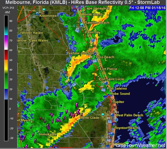
El Nino Could Weaken For 2016 Hurricane Season
Good Sunday evening everybody. There is an old saying that what goes up must come down. That is going to be the case with the present El Nino that is affecting our weather this winter. The El Nino protected us well this past hurricane season by creating strong upper level winds that protected us from hurricanes.
As you know, El Nino is a warming of the waters of the tropical Pacific. This warming then in turn affects weather patterns throughout the world. It normally helps to protect us from hurricanes by increasing the wind shear in the tropical Atlantic.
Category: Tropic Watch 2015 |
Tracking Invest 92 In The Caribbean.
We are now tracking Invest 92. The broad area in the Caribbean has finally got the attention of the NHC and is now being monitered. 
Over the past couple of weeks, models have been hinting at some activity in the Gulf. These models have been consistent and ip appears they will be correct. Even if the low devellops, it has to move across the Yucatan Penninsula before emerging into the Gulf of Mexico. This could seriously disrupt the circulation.
Category: Invest 92 (Atlantic), Tropic Watch 2015 |
Potential Tropical Activity Near Florida Late October
Good evening everybody. Right now the tropics are quiet but both the Euro and the GFS are insisting of a tropical entity in the Gulf in the October 20 – 25 time period. this is the leates GFS model run which confirms this. Although a long way out, we will be watching this closely.
A History of Lake Okeechobee and The Important Part It Plays In Our Weather
Lake Okeechobee is one of the most talked about lakes in the United States. It has a rich history that dates back 6,000 years. It has always been a major source of water for Florida. Some of Florida’s first descendants lived near the great lake many, many years ago. The name Okeechobee means “big water”.
In the early days of the Lake, there were no waterways leading to of from the lake. When the lake overflowed, the water would stream south into the area that is now known as the Everglades. This was the natural pattern before man stepped in and starting building dams and locks.
Tornado Watches Issued From Orlando, Florida South
URGENT – IMMEDIATE BROADCAST REQUESTED
TORNADO WATCH NUMBER 27
NWS STORM PREDICTION CENTER NORMAN OK
1125 AM EST THU MAR 6 2014
THE NWS STORM PREDICTION CENTER HAS ISSUED A
* TORNADO WATCH FOR PORTIONS OF
THE CENTRAL AND SOUTHERN FLORIDA PENINSULA
COASTAL WATERS
* EFFECTIVE THIS THURSDAY MORNING AND EVENING FROM 1125 AM UNTIL
700 PM EST.
* PRIMARY THREATS INCLUDE…
SEVERAL TORNADOES POSSIBLE
SEVERAL DAMAGING WIND GUSTS TO 70 MPH LIKELY
SEVERAL LARGE HAIL EVENTS TO 1 INCH IN DIAMETER POSSIBLE
Radar Model Forecasts for Florida Precipitation
Simulated radar over the next 2 days. The first frame shows the front approaching around 4 PM tomorrow. The second frame represents the radar around 6 PM tomorrow. The third frame represents around 8 PM tomorrow night and the final frame shows around 10 tomorrow night. You can see by the model the precipitation overspreads most of the area around 8 PM. This is not a forecast, it is a model run and great differences in the precipitation and/or timing could be realized.
For Real time radar loops for Florida:
http://www.joesdiscoweathercentral.com/Florida_Doppler_radar_Loops.html
Category: Weather Watch 2014 |
Tags: Florida
Potential For Strong Storms Tomorrow Along the Treasure Coast in Florida
Good morning Treasure Coast!! Looks like the weather will become increasingly unsettled over the next couple of days.
The cold front will linger across our region for most of the day today. The boundary will slowly move back to the north this evening and through the overnight hours. This will increase the precipitable water values through the day which may trigger some scattered showers today. There could be a rumble of thunder.
Category: Weather Watch 2014 |
Watch Out Treasure Coast, Florida on Thursday.. Potential Severe Weather
Good evening Treasure Coast!! As mentioned in an earlier post, an area of low pressure is expected to develop over the Gulf of Mexico on Wednesday. This area is forecast to move over north Florida on Thursday.
There is a potential for strong to severe storms to develop across the East Central Florida area on Thursday. In addition, a strong cold front will move through along with the line of storms.
The temperatures will be slightly cooler on Friday with a high about 71. Thursdays high will be in the low 80’s.
Hurricane Season 2014 Initial Projections
It is only February but us weather folk are already looking at the 2014 hurricane season. As of today, we have not seen a major hurricane hit in Florida since hurricane Wilma in 2005. That is a long stretch and is actually somewhat unusual. The big question is what are the predictions for this year? Well, 2014 may not be an active season since our friend, El Nino, may take shape by the peak of the tropical cyclone season.
Category: Tropic Watch 2014 |
Tags: hurricane season 2014
What To Do In Case Of A Tornado
With todays crazy weather, tornado and other severe weather events are becoming increasingly common. If you live in an area that receives bad weather a good part of the time, then you are probably well versed on what you should do. If you live in an area that only sees tornadic activity on occasion, you might want to watch this video from the American Red Cross. It gives some great tips on how to handle most common situations.
For the latest weather information for your area, visit us at:
Mid Atlantic Readies For Major Winter Storm
Winter storm watches and warnings are in place for much of the Eastern US tonight as a major winter storm promises to create havoc. This system could be extremely disruptive for both commuters and travelers Flights are already cancelled going into Atlanta, which is a major hub for travelers.
The system will be bringing a combination of ingredients including ice and sleet in the south to heavy wet snow in the north east.
Category: Winter Season 2014 |
Tags: new england, new jersey, north carolina, south carolina, winter storm
Potential Ice Storm Heading For New Jersey
The combination of low pressure developing in the Mississippi Valley and low pressure off the Carolina coast will be monitored through the night to be sure the forecast and development are on track. The potential for a significant ice storm event is possible.
For starters, the precipitation will start as snow in most locations. However, the track of the surface low will shortwave aloft will will result in good SW flow which will warm the upper levels of the atmosphere. This warming will change the precipitation to a sleet and freezing rain mix. The expectation is for moderate to heavy precipitation.
Significant Snowfall Possible In Southern New England
A significant snowfall event is possible across much of Southern New England as a low pressure area tracks between Nantucket and the 40N/70W location. In addition, another snow event is possible over the weekend.
Overall, there is significant confidence that a winter storm will impact the souther New England area. The expected impact will be late Tuesday night through Wednesday.
There is some uncertainty with snowfall totals as the models tend to shift back and forth in regard to the air temperatures. This can make a significant difference either way in the snow totals.
Treasure Coast Rain Chances At 100% Today 1/30/2014
**Rainfall Amounts For The Treasure Coast**Rainchances at 100% for Today****
This is a list of cities with the corresponding rainfall amounts for each over the last 24 hours. This list does not include what still might be coming later this morning and afternoon. The rain chances along the Treasure coast for today is 100%.
Cloudy and cool conditions will prevail today in association with a weak low pressure area that has developed offshore. Light to moderate rain will persist through the day as this moisture plume streams across the Florida peninsula from the Gulf of Mexico. Locally heavy rainfall is possible in some locations.
The Deep South Tries To Recover After Rare Winter Storm
A rare winter storm has left the deep all but paralyzed. Snow, freezing rain and sleet have made many roads slick and in some cases almost impossible to navigate. As many as 50 million Americans have been affected by this freak winter storm.
In the cities of Atlanta and Birmingham traffic is still at a gridlock with some folks still trapped in their cars since yesterday. Many just abandoned their cars and headed to shelters.
Rare Winter Storm Headed To The Southeast States
Some major normally warm weather tourist areas are going to be hit with a rare Winter storm. Places such as Charleston, SC, Savannah, Ga., Pensacola, Fla., and New Orleans are going to receive a mixture of snow and ice Tuesday and Wednesday. Some schools are already planning half days and will likely be closed tomorrow in advance of the severe weather. More then 1,800 flights have already been cancelled.
Winter Storm Watches For Parts of North and South Carolina
***Winter Storm Watch for North and South Carolina***
In an unusual weather scenario, Winter Storm watches have been issued for parts of North and South Carolina. The areas affected include South East North Carolina and North East North Carolina.
Hazards include freezing rain, snow and sleet. The risk for accumulating snow is increasing. Up to three inches is possible in some locations along with freezing rain.
The bulk of the weather is expected on Tuesday night. Winds will gust up to m30 MPH with temperatures in the 20’s. This will create wind chills as low as 10 degrees!
The Polar Vortex Returns With A Vengeance
The cold weather just will not let up. The next Polar Vortex is on the way to a city near you. If you live in the Midwest or Northeast, it is going to be a cold week. Looking at the low temperatures, we could see some below freezing temperatures as far south as North Florida.
Similar to the last polar blast, the coldest temperatures of this event will be in the Plains and the Northeast states.
Category: Winter Season 2014 |
Tags: polar vortex
Freeze Warnings For The Treasure Coast in Florida
****Freeze Warnings Issued For The Treasure Coast******
A freeze warning is in effect from 1 AM to 8AM Friday morning. This is the first bout of freezing or near freezing weather for our region. In addition, a freeze watch is in effect for the Palm Beach area. Most areas to our north will also be under the freeze warning.
For the Treasure Coast, the freeze warning is for locations West of US 1 and even more so the farther inland you go.
Category: Winter Season 2014 |
Our Website and Java…Site Is Now Converted To Flash!
Update….All our radars have now been converted to Flash as of 2/26/14!
Like many websites, our website uses the Java platform for some of our messaging features and radar loops. To make the program more secure, Oracle has added security measures that make it harder to run anything that is Java based. Our site uses known safe and trusted scripts that are only used when absolutely necessary to get the weather information to you. Our primary use of Java is with our unique radar loops. Our loops are unique in the fact that they contain lots of information that can be useful for not only a homeowner or business but also to storm trackers. These loops currently can only be displayed with Java.
Your Forecast Discussion For The Treasure Coast
Tonight a high pressure ridge that is centered over the NE Gulf of Mexico is embedded within a deep Westerly flow that will slide it across the deep south and into the West Atlantic tonight. This will produce a dry and stable air mass tonight. Temperatures will generally be in the 50’s overnight in most locations.
Tomorrow, a ridge axis will a short wave trough to develop in the Plains and push into the deep south. The winds will then switch to the South – Southwest and allow the cold front that just passed to return as a warm front. Temperatures will be above average witth highs in the 80’s.
Category: Weather Watch 2014 |
Cold Temperatures Headed To The Treasure Coast Of Florida
**Treasure Coast Temperatures To Be The coldest On Monday Night**
Step right up and get your ticket for the Temperature Roller Coaster coming to a thermometer near you.
After a high tomorrow of 79 degrees, the temperature will rapidly drop tomorrow night to a low of 39 degrees. Could be a couple degrees either side of that temperature depending on where you live.
Category: Winter Weather 2013 |
Heavy Snow Heading Towards the North East Today and Tonight
***The Largest North East Storm Of The Season Poised To Strike Today and Tomorrow****
Heavy snow and extremely low temperatures are coming to the North East today. Areas such as Boston and Long Island along with the Cape in Massachusetts are going to be in the epi-center of the storm. Blizzard warnings are in effect for parts of Long Island and the Cape for strong winds with blowing snow later today and tonight. Snow is already falling from moisture coming off the water in Boston and other coastal areas in Massachusetts.
Category: Uncategorized |
Tags: Winter Season 2014
North East Winter Storm Is A Certainty
***Dangerous Winter Storm To Affect The North East States From Northern New Jersey Through New England. ***
Some cities in the affected area include Springfield, Boston and most of Long Island.
The Winter Storm warning is in effect from 4 AM Thursday through 10 AM Friday. Snow accumulations of 6 to 10 inches or more possible.
Heavy snow and gusty winds will result in very dangerous wind chills with blowing and drifting snow. Near blizzard conditions are possible and travel may become impossible.
Category: Weather Watch 2014 |
Potential Winter Storm For The North East As The New Year Begins
Good morning all. The models are indicating that a snow storm could be in the works for the North East later this week. The models have been quite consistent in ringing in the New Year with a Winter Storm. As usual, there are several model solutions but one of the most reliable and most accurate, The Euro, is showing the storm move right up the coast.
Category: Weather Watch 2013 |
Rain Likely Today Along The Treasure Coast Of Florida
***Rain Likely Today Along the Treasure Coast***
Rainy and blustery conditions will develop today along the Treasure Coast and other parts of Florida today. The ran chances are at 70% today. The new updated forecast puts a chance of showers all the way through New Years Day. The rain chances will be less on New Years but will stand at around 30%. It looks like today will be the wettest day of all.
The high today will be near 81 and the highs for the rest of the week through New Years will be 75.
Category: Weather Watch 2013 |
Tags: treasure coast
Washington, Illinois Tornado Video Is One Of The Most Intense Videos We Have Seen.
This is one of the most terrifying and emotional videos of a tornado that I ever seen. We are so glad that everybody got out OK. This is just a reminder on how fast Mother Nature can turn from good to bad in a very short time. The video is from Washington, Illinois.
Potential Thanksgiving Winter Storm
The chances of a potential Thanksgiving winter storm for the East Coast is getting a bit stronger as time goes on. The GFS model is showing an area of low pressure developing in the Gulf of Mexico in about 72 hours or so. The low could bring bad weather to Louisiana and Mississippi. As the low intensifies, Georgia and the Carolinas could be next on the list with flooding rains possible.
Category: Winter Weather 2013 |
Tags: east coast winter storm
Sub-Tropical Storm Melissa Forms in Atlantic
A late season storm has formed in the Atlantic and it could become a hurricane. The storms name is sub-tropical storm Melissa. Fortunately she will stay right where she belongs and that is in the Atlantic. Melissa will be stirring up the surf especially around Bermuda and the Bahamas but she will pose no threat to any land areas.
Melissa is currently sub-tropical but a full tropical transition is expected. This transition will happen by Tuesday.
Winds are currently 60 MPH with a minimum pressure of 987MB.
Uniden To Premier A New Line Of Police Scanners
Uniden has announced a new line of police scanners today! We have been using Uniden scanners for years to bring you the live St. Lucie County police scanner action that we provide. There is no word on exactly what new features will be offered but they are coming out just in time for the holiday season. I know I will be watching, will you?
Police scanners can be very useful during severe weather events alerting to streets that might be flooded, tornado sightings and road closures. They should be a part of your emergency weather kit.
The Tropics Still Have Some Life
Late season tropical outlook. I know it is November but the disturbed area of weather in the Caribbean that the models showed us last week has materialized. Although conditions are are not great for development at this time, we will continue to monitor the area for you. Remember that hurricane season lasts till November 30.
Category: Tropic Watch 2013 |
Tags: tropical outlook
Super Storm Sandy One Year Later
One year ago today, a hybrid storm called Super Storm Sandy hit the North East with high winds and an extreme storm surge. Usually when a nor’ easter or hurricane hits this area it stays just offshore or makes landfall in Long Island and moves north or north east.
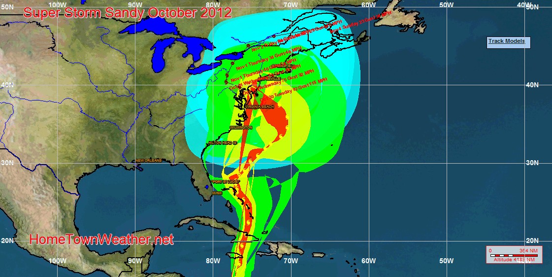
With Sandy, this did not happen. A blocking high pressure area to the north and east of the region blocked the system and forced it to do the unthinkable and head right into the Jersey coast.
Category: Hurricane Sandy |
Tags: super storm sandy
Super Storm Sandy Slammed The North East One Year Ago Today
One year ago today, Super Storm Sandy devastated the East Coast of New Jersey and severely flooded the New York City area. Today, there are no tropical systems being monitored in the Caribbean but the clean up and rebuilding still continue in many parts of the North east.
Category: Hurricane Sandy |
Tags: super storm sandy
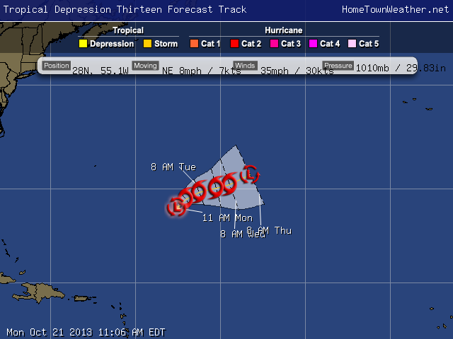
Tropical Depression 13 Forms Near Bermuda
**Tropical Depression 13 Forms Near Bermuda*** There are no coastal watches in effect. The area continues to increase in organization this morning. The system will pose no threat to land and it will be a short lived storm. The system will be whisked out to the north-east and then north until dissipation occurs. There is a potential for some modest intensification over the short term. http://
Category: tropical depression 13 |
Tags: Tropical Depression 13
Florida Dry Season Is Officially Here!
Official Florida Dry Season Has Begun…
We can now say we are in the dry season for Florida. Gone are daily afternoon thunderstorms and downpours. That is not to say we will not see days with some showers or thunderstorms but they will be a lot less frequent. Most of the rain we see from now on will be associated with frontal troughs.
Category: Weather Watch 2013 |
Tags: Florida dry season
Tornado Watches Cancelled
WATCH COUNTY NOTIFICATION FOR WATCH 543
NATIONAL WEATHER SERVICE MOUNT HOLLY NJ
403 PM EDT MON OCT 7 2013
ANZ430-431-450>455-072115-
/O.CAN.KPHI.TO.A.0543.000000T0000Z-131007T2100Z/
THE NATIONAL WEATHER SERVICE HAS CANCELLED TORNADO WATCH 543 FOR
THE FOLLOWING AREAS
THIS CANCELS THE FOLLOWING ADJACENT COASTAL WATERS
Category: Weather Watch 2013 |
Tens of Millions Under Tornado Watch
This morning most of the Eastern US is under a tornado watch from Washington DC through much of the North East.
WATCH COUNTY NOTIFICATION FOR WATCH 543
NATIONAL WEATHER SERVICE BALTIMORE MD/WASHINGTON DC
911 AM EDT MON OCT 7 2013
DCC001-MDC003-005-009-013-017-021-025-027-031-033-043-510-VAC059-
061-107-153-510-600-683-685-072100-
/O.CON.KLWX.TO.A.0543.000000T0000Z-131007T2100Z/
TORNADO WATCH 543 REMAINS VALID UNTIL 5 PM EDT THIS AFTERNOON FOR
THE FOLLOWING AREAS
THE DISTRICT OF COLUMBIA
IN MARYLAND THIS WATCH INCLUDES 11 COUNTIES
IN CENTRAL MARYLAND
ANNE ARUNDEL HOWARD MONTGOMERY
PRINCE GEORGES
Category: Weather Watch 2013 |
Tags: tornado watch
Tropical Storm Karen Friday Morning Update
Some interesting changes in at least one of the models for Tropical Storm Karen this morning. The GFS is showing the cyclone taking a more Easterly track and hitting somewhere around Apalachee Bay and then stalling off the South Carolina Coast. We will have to watch carefully for any signs of this eastward trend as the day progresses.
In general, Karen is actually a “mess” right now with the effects of the wind shear apparent. The main convection is well east of the center. The central pressure has risen from 999 mb to 1002 mb.
Tropical Storm Karen Remains A Sheared Cyclone
Tropical storm Karen remains a sheared cyclone but is maintaining a very vigorous circulation. Most of the thunderstorm activity is to the north and east of the center. The intensity remains at 65 MPH with some slight strengthening possible before a weakening trend begins before landfall.
According to NOAA aircraft, Karen is moving to the North-Northwest at 9 knots.
Currently, a narrow ridge over Florida is keeping Karen away from the state. This ridge is expected to weaken and allow a more northerly component to Karen. Thereafter, Karen will begin to re curve to the north east.
Tropical Storm Karen Remains Unchanged at 5 PM
Tropical Storm Karen…Hurricane watches in the Panhandle have been changed to Tropical Storm Watches. Hurricane watches are in effect for parts of the Central Gulf.
Karen has not significantly changed this afternoon. She is being plagued by dry air and wind shear. Despite all the negative elements, Karen continues too maintain her intensity. Recon measured an internal pressure of 999MB. The last run still supported maintaining the system as a tropical storm.
Only slight strengthening is expected due to the negative factors and then some weakening is possible as the system comes ashore.
Tropical Storm Karen Forms In Caribbean…Nearing Hurricane Strength
Tropical Storm Karen has formed. A hurricane watch is in effect for the Northern Gulf Coast. There is no threat to East Central Florida. Maximum winds are 65 MPH.
Invest 97 May Be Soon Called Karen
Invest 97 is gaining good banding features and advisories might be issued on this system at any time. It appears that the system will miss or just skirt the Yucatan which will keep it over water. The models are still quite consistent with a track near the Panhandle of Florida. Heavy rain on the outer bands could affect a good part of Florida and increase the rain chances.
Some wind shear is expected to affect the system in the Gulf so that might help to control the development. Interests in the northern Gulf are advised to keep posted on the progress of what will soon be Karen.
Potential Problems For The Gulf Later This Week
***Tropical Outlook***
Tropical Storm Jerry is meandering aimlessly in the far Atlantic and will pose no threat to land.
Closer to home, Invest 97 has jumped way up in the potential for development overnight. In addition, model runs have changed as well. Most of the models are showing a decent size storm hitting somewhere along the Gulf Coast from the Panhandle of Florida to near Louisiana. I just ran a simulated satellite model over the next week and it shows the system in the Gulf region around Friday or Saturday. Remember that once the system gets better organized, a better handle on the exact track will be evident.
Category: Tropic Watch 2013 |
Potential Tropical Threat for Eastern Gulf next Week
**Special Tropical Outlook****
An area of low pressure has formed in the Caribbean and it has caught the attention of the NHC.
This area is in a location that could be conductive for development and is forecast by global models to enter the Gulf Of Mexico and be near the West Coast of Florida in about a week. As of now, the models are showing a weak tropical system but a lot can happen over the next few days as the area progresses.
Category: Tropic Watch 2013 |
The Tropics Remain Quiet and Cooler Weather For Florida
The promised cooler weather has finally arrived and wow does it feel good. I just ran the latest ECMWF model (Euro) and we do not see anything of a tropical nature forming through next Monday. This time of year, we look to the Caribbean area for tropical development. We are past the long tracker type of storms that come off of Africa. There is plenty of warm water but it appears the atmospheric conditions are just not there. Could we be past the point of worry for the season? Quite possibly but We still have the entire month of October to watch. Remember that some farly potent storms have developed in October over the years and it seems that storms in October have been getting a bit more frequent. Do not put the tracking map away just yet!
Category: Tropic Watch 2013 |
Tags: Quiet Tropics
Flood Watch For East Central Florida Is Cancelled
WGUS62 KMLB 251832
FFAMLB
FLOOD WATCH
NATIONAL WEATHER SERVICE MELBOURNE FL
232 PM EDT WED SEP 25 2013
…FLOOD WATCH IS CANCELLED…
FLZ041-044>047-053-054-058-059-064-141-144-147-251945-
/O.CAN.KMLB.FA.A.0003.000000T0000Z-130926T0000Z/
/00000.0.ER.000000T0000Z.000000T0000Z.000000T0000Z.OO/
INLAND VOLUSIA-NORTHERN LAKE-ORANGE-SEMINOLE-SOUTHERN BREVARD-
OSCEOLA-INDIAN RIVER-OKEECHOBEE-ST. LUCIE-MARTIN-COASTAL VOLUSIA-
SOUTHERN LAKE-NORTHERN BREVARD-
INCLUDING THE CITIES OF…DE LAND…LEESBURG…ORLANDO…
SANFORD…MELBOURNE…PALM BAY…KISSIMMEE…ST CLOUD…
VERO BEACH…OKEECHOBEE…FORT PIERCE…HOBE SOUND…
DAYTONA BEACH…CLERMONT…TITUSVILLE
232 PM EDT WED SEP 25 2013
…FLOOD WATCH IS CANCELLED…
THE FLOOD WATCH FOR EAST CENTRAL FLORIDA HAS BEEN CANCELLED.
Category: Weather Watch 2013 |
Florida Flood Watches Continue Through Tonight
***Flood Watch Continues Through Tonight***
Hi everybody. We are still under a flood watch today through this evening. There is still lots of convection off the West Coast of Florida to move across our region. Some of the heaviest rain moving across right now appears that it will stay just north of Ft. Pierce as it slides across the state. Most of the heavy rain is expected later this afternoon into tonight.
Precipitable water soundings show a very moist atmosphere with water values at around 2.4 inches. This number should again lead to some excessive rain fall today.
Category: Weather Watch 2013 |
Flood Watch Continues For All Of East Central Florida
…FLOOD WATCH REMAINS IN EFFECT THROUGH TUESDAY EVENING…
THE FLOOD WATCH CONTINUES FOR
* ALL OF EAST CENTRAL FLORIDA…INCLUDING THE FOLLOWING COUNTIES…
BREVARD…INDIAN RIVER…LAKE…MARTIN…OKEECHOBEE…ORANGE…
OSCEOLA…SEMINOLE…SAINT LUCIE…AND VOLUSIA…
* THROUGH TUESDAY EVENING
* WIDESPREAD RAINFALL AMOUNTS…INCLUDING TO DAY’S HEAVY RAINFALL…
WILL TOTAL TWO TO FOUR INCHES THROUGH SUNSET TUESDAY EVENING.
LOCATIONS THAT RECEIVED THE HEAVIEST RAINFALL TO DAY COULD WIND
UP WITH RAINFALL TOTALS UP TO 6 INCHES.
* THE HEAVY RAINFALL THREAT COULD CONTINUE TUESDAY NIGHT INTO
WEDNESDAY. LISTEN FOR FURTHER INFORMATION…INCLUDING A POSSIBLE
EXTENSION OF THE FLOOD WATCH.
Category: Weather Watch 2013 |