Archive for Treasure Coast Forecast

Treasure Coast | April 29, 2017 Forecast | Florida |

Good Saturday morning Treasure Coast! Very dry air exists along the Treasure Coast today. A few showers near the immediate coast is possible later today into tonight.

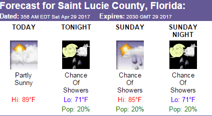
The high today will be around 90 with very low rain chances. Saturday night looks pleasant with lows around 70. Sunday, the shower chances are up just a bit to 20%. The high on Sunday will be in the mid 80’s. As we migrate to next week, the rain chances are bumped up to 40% on Tuesday and Friday.

Weather | Treasure Coast Forecast 3/11/17

Good Saturday morning Treasure Coast!! Some changes are in store for the region over the next few days with cooler temperatures and a greatly enhanced chance of rain.

A weak cool front has moved through the area this morning. High pressure will build to the north and will increase the winds from the E/NE. Highs today will reach the low to mid 80’s.

The cold front will move around Lake Okeechobee and then stall overnight. The front will then begin to move north as a warm front. The onshore flow will begin to pump moisture into the area and will increase the rain chances.

Steady Rain Possible Along The Treasure Coast in Florida

Good morning Treasure Coast! Do you miss summer? Well today might give you a taste of it again. Temperatures could soar to the upper 80’s in some areas today.

A warm and humid airmass will be in place. A passing thunderstorms is possible especially along the sea breeze boundary. Very similar to a summer day. Coverage will be isolated but a rumble cannot be ruled out. Storm motion today will be towards the North East today.

Strong Cold Front To Move Through Florida

Good Monday morning Treasure Coast!! Although we are not in a tornado watch area, a line of rain and storms will likely move across our region ahead of a strong cold front. Tornado watches are in place for parts of the Florida Panhandle at this hour.


Today, a strong cold front will approach East Central Florida and will move through the area by late tonight. We could see some lightning storms develop ahead of this frontal system along with heavy rain and wind gusts to 50 MPH.

Bertha Downgraded | Treasure Coast Rain

Good morning Treasure Coast and East Central Florida. Bertha is now back to a 60 MPH tropical storm. She is spinning harmlessly in the Atlantic and will not affect anybody directly. She will increase in rip current threat along the beaches, however. Caution is advised if you are planning on swimming in the Atlantic today.

Scattered to numerous showers and thunderstorms are possible today with the highest concentration along the Space and Treasure Coast areas. The rain chances today stand at 60%.Slightly lower then yesterday but not by much.

Bertha Becomes A Hurricane. No Threat To Land

**Tropical Update***

As of 11 AM Bertha has become our second hurricane of the 2014 season. Since we are only about a third of the way into the season, we could see several more before all is said and done. The conditions were right to keep this system away from the US mainland. A combination of an offshore subtropical ridge and a trough over Florida helped to steer Bertha away from any land areas.

Bertha will have no direct effects on land with the exception of some rough surf and a higher risk of rip currents.

High Rain Chances For Treasure Coast on Monday

**Treasure Coast Forecast***
High rain chances tomorrow with the combination of a low pressure trough over Florida and Bertha well offshore the Florida Coast. Bertha will remain about 349 miles off the coast of Florida at the closest pass.

The rain chances tomorrow will be in the 60 to 70% range.Temperatures will reach the low 90’s in most locations.

On Tue, rain chances will continue above seasonal averages as Bertha moves away from the area. Rain chances will be in the 50% range.

Treasure Coast Forecast…Aug. 2, 2014

Good afternoon Treasure Coast. Today will be the driest day of the week.With that said, moisture values will be high enough for scattered showers this afternoon. The coverage will not be widespread but showers are certainly possible.

For Sunday and Monday, a mid level trough extending from the Great Lakes to the Gulf will keep the typical sub-tropical ridge suppressed. This scenario with suitable moisture will produce scattered to numerous showers and thunderstorms, especially on Monday.

East Central Florida Forecast July 18, Friday

Good morning Florida! An out of cycle cold front will bring unusually dry air to the Sunshine State today. Rain chances are cranked all the way down to 20% forĀ today. A look at the water vapor satellite shows very low moisture levels over Florida today. The front that brought the dry air has mostly decayed so it will not affect the temperatures although it will feel cooler because of the dry air. Temperatures will still go up into the 90′;s. If you have outdoor activities or chores to do, today is the day.

Treasure Coast Forecast for July 15, Updated

Good morning Treasure Coast. The rain chances have again been bumped up to about 60% for today. The Hi Res radar model is showing lots of activity stating earlyin South Florida from Palm Beach south. It shows some pretty strong stuff around West Palm. Expect showers to develop almost anytime today. The model also shows a line of storms moving through the Treasure coast later tonight about 9 PM. We will have to see if this transpires.

Your Source for Treasure Coast, Florida Forecasts and Radar!Treasure Coast Forecast