Archive for Winter Season 2015

Blizzard Warning Update….

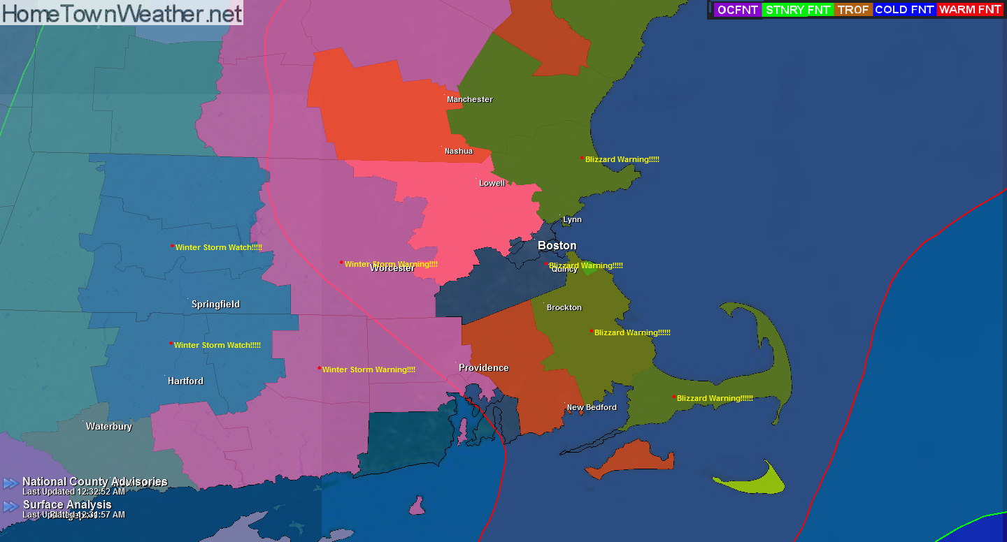
***Blizzard Warning update**** Eastern Massachusetts

Hazard Types: Blizzard conditions including heavy snow, poor visibility and strong damaging winds

Accumulations of 10 to 14 inches.

Timing: Saturday night into Sunday…

Travel will become nearly impossible and potentially life threatening!

White out conditions are possible with winds 30-40 MPH with gusts to 75.

Temperatures will be around 20 degrees.

Massachusetts Radar and Forecast:
http://www.massachusettsradar.com/

New York/New Jersey Forecast and Radar:
http://www.joesdiscoweathercentral.com/New_York_and_Vicinit…


warnings

***Blizzard Warnings for Coastal Massachusetts***

***Blizzard Warning!!*** Blizzard warning issued for Boston and other areas along the East Coast of Massachusetts. Heavy snow is forecast elsewhere!

Winter Storm Watch has been issued for areas farther inland including the city of Springfield!!

NATIONAL WEATHER SERVICE TAUNTON MA
318 PM EST FRI FEB 13 2015

…WINTER STORM WILL BRING BLIZZARD CONDITIONS TO EASTERN
MASSACHUSETTS THIS WEEKEND AND HEAVY SNOW FARTHER INLAND…

MAZ006-007-015-016-019-022-024-140430-
/O.UPG.KBOX.BZ.A.0002.150215T0000Z-150216T0000Z/
/O.NEW.KBOX.BZ.W.0002.150215T0000Z-150215T1600Z/
WESTERN ESSEX MA-EASTERN ESSEX MA-SUFFOLK MA-EASTERN NORFOLK MA-
EASTERN PLYMOUTH MA-BARNSTABLE MA-NANTUCKET MA-
INCLUDING THE CITIES OF…LAWRENCE…GLOUCESTER…BOSTON…
QUINCY…PLYMOUTH…CHATHAM…FALMOUTH…PROVINCETOWN…NANTUCKET
318 PM EST FRI FEB 13 2015

Blizzard Watch/Winter Storm Watch Continues for Mass.

Good evening everybody. Blizzard watches continue for parts of SE Massachusetts tonight. Elsewhere, a Winter Storm Watch is in effect.

The first Graphic shows the areas under watches and warnings. The pressure model graphics located below show the low and the potential wind speeds associated with it.


watches

NATIONAL WEATHER SERVICE TAUNTON MA
1030 PM EST THU FEB 12 2015

…SNOW ENDS TONIGHT…COLD WEATHER FOLLOWS…
…BLIZZARD CONDITIONS POSSIBLE THIS WEEKEND ALONG THE EAST COAST…

Wind Chill Advisory Hamden County, Mass.

NATIONAL WEATHER SERVICE TAUNTON MA
414 PM EST THU FEB 12 2015

…SNOW ENDS TONIGHT…COLD WEATHER FOLLOWS…BLIZZARD CONDITIONS
POSSIBLE FOR THE WEEKEND…

MAZ002-008-009-130515-
/O.EXT.KBOX.WC.Y.0006.150213T0500Z-150213T1900Z/
WESTERN FRANKLIN MA-WESTERN HAMPSHIRE MA-WESTERN HAMPDEN MA-
INCLUDING THE CITIES OF…CHARLEMONT…CHESTERFIELD…BLANDFORD
414 PM EST THU FEB 12 2015

…WIND CHILL ADVISORY NOW IN EFFECT FROM MIDNIGHT TONIGHT TO
2 PM EST FRIDAY…

* LOCATIONS…WESTERN MASSACHUSETTS.

* HAZARD TYPES…BITTERLY COLD WIND CHILL VALUES.

* WIND CHILL READINGS…AS LOW AS 22 BELOW.

* TIMING…LATE TONIGHT INTO MIDDAY FRIDAY.

Winter Storm Watch Worcester, Mass

NATIONAL WEATHER SERVICE TAUNTON MA
414 PM EST THU FEB 12 2015

…SNOW ENDS TONIGHT…COLD WEATHER FOLLOWS…BLIZZARD CONDITIONS
POSSIBLE FOR THE WEEKEND…
MAZ004-012-RIZ001-130515-
/O.NEW.KBOX.WS.A.0007.150214T2000Z-150216T0000Z/
/O.CON.KBOX.WC.Y.0006.150213T0800Z-150213T1600Z/
NORTHERN WORCESTER MA-SOUTHERN WORCESTER MA-
NORTHWEST PROVIDENCE RI-
INCLUDING THE CITIES OF…BARRE…FITCHBURG…MILFORD…
WORCESTER…FOSTER…SMITHFIELD
414 PM EST THU FEB 12 2015

…WIND CHILL ADVISORY REMAINS IN EFFECT FROM 3 AM TO 11 AM EST
FRIDAY…
…WINTER STORM WATCH IN EFFECT FROM SATURDAY AFTERNOON THROUGH
SUNDAY EVENING…

THE NATIONAL WEATHER SERVICE IN TAUNTON HAS ISSUED A WINTER STORM
WATCH…WHICH IS IN EFFECT FROM SATURDAY AFTERNOON THROUGH SUNDAY
EVENING.

Blizzard Watch for Eastern Massachusetts

NATIONAL WEATHER SERVICE TAUNTON MA
414 PM EST THU FEB 12 2015

…SNOW ENDS TONIGHT…COLD WEATHER FOLLOWS…BLIZZARD CONDITIONS
POSSIBLE FOR THE WEEKEND…
MAZ022-024-130515-
/O.NEW.KBOX.BZ.A.0002.150215T0000Z-150216T0000Z/
/O.CON.KBOX.WW.Y.0013.000000T0000Z-150213T1200Z/
BARNSTABLE MA-NANTUCKET MA-
INCLUDING THE CITIES OF…CHATHAM…FALMOUTH…PROVINCETOWN…
NANTUCKET
414 PM EST THU FEB 12 2015

…WINTER WEATHER ADVISORY REMAINS IN EFFECT UNTIL 7 AM EST
FRIDAY…
…BLIZZARD WATCH IN EFFECT FROM SATURDAY EVENING THROUGH SUNDAY
EVENING…

THE NATIONAL WEATHER SERVICE IN TAUNTON HAS ISSUED A BLIZZARD
WATCH…WHICH IS IN EFFECT FROM SATURDAY EVENING THROUGH SUNDAY
EVENING.

* LOCATIONS…CAPE COD AND NANTUCKET.

More Snow For New England?

The answer to the title question is yes. More snow is on the way to New England. A low pressure will form south of New England late tonight and intensify offshore. This will bring light snow to the region. The winds will create dangerous wind chills tonight.

The bigger story will be this coming weekend. There is a potential for another strong coastal storm. Blizzard conditions are possible for the coastal New England. Then, some of the coldest air of the season will overspread the area. Yet another storm is forecast by midweek. These are the three lows that I pointed out in an earlier post on Facebook.

Winter Storm Watch for New York/New Jersey

Winter Storm Watch for New York/New Jersey area.

URGENT – WINTER WEATHER MESSAGE
NATIONAL WEATHER SERVICE MOUNT HOLLY NJ
358 PM EST SAT JAN 31 2015

…A SIGNIFICANT WINTER STORM IS POSSIBLE FROM LATE SUNDAY INTO
MONDAY…
NJZ012-PAZ101-011000-
/O.EXA.KPHI.WS.A.0002.150202T0000Z-150202T1800Z/
MIDDLESEX-WESTERN CHESTER-
INCLUDING THE CITIES OF…NEW BRUNSWICK…HONEY BROOK…OXFORD
358 PM EST SAT JAN 31 2015

…WINTER STORM WATCH IN EFFECT FROM SUNDAY EVENING THROUGH
MONDAY AFTERNOON…

THE NATIONAL WEATHER SERVICE IN MOUNT HOLLY HAS ISSUED A WINTER
STORM WATCH. IT IS IN EFFECT FROM SUNDAY EVENING THROUGH MONDAY
AFTERNOON.

Another Major Winter Storm for New England

**Major Winter Storm Expected for New England late Sunday through Monday****
****Heavy Snow….8 to 14 inches****

As you can see in the precipitation graphic, areas to the south including New Jersey and New York will likely start out as snow but then a mix will later develop. New England should see all snow.

The Snow Depth graphic from the GFS model gives an idea what to expect in the way of snow accumulations.

NATIONAL WEATHER SERVICE TAUNTON MA
323 PM EST SAT JAN 31 2015

More Snow Possible For The Northeast

Good evening everybody! If you live in the North East I am sure you have been seeing your fair share of snow and winter weather. The truth is that more is on the way in the form of a winter storm Sunday and Monday. The forecast amounts are going to change in the coming days but it looks as if it could be significant and plowable. (See graphic) This system will be nothing like the blizzard that just hit the region but some gusty winds are possible. Since this snow will be accumulating over snow that has already fallen, the totals on the ground will be quite high.

Your Source for Treasure Coast, Florida Forecasts and Radar!Treasure Coast Forecast