
It looks like the Winter Storm that all the models have been hyping the last couple of weeks is going to be a reality. This storm will affect a large swath of the Mid Atlantic in a full range of Winter Weather. Freezing rain will be an issue in North Carolina near the coast while farther inland, Winter Weather advisories will be in place. Along the Jersey Shore, a coastal flood watch has been issued for the possibility of major coastal flooding, especially from Atlantic County south.
Tag Archive for blizzard watch
Major Winter Storm To Hit Mid Atlantic Region
Category: Winter Weather 2016 |
Tags: blizzard watch, coastal flood watch, new jersey, Washington DC, winter storm
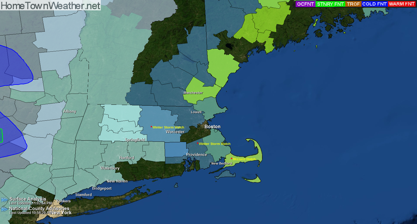
Blizzard Watch/Winter Storm Watch Continues for Mass.
Good evening everybody. Blizzard watches continue for parts of SE Massachusetts tonight. Elsewhere, a Winter Storm Watch is in effect.
The first Graphic shows the areas under watches and warnings. The pressure model graphics located below show the low and the potential wind speeds associated with it.
NATIONAL WEATHER SERVICE TAUNTON MA
1030 PM EST THU FEB 12 2015
…SNOW ENDS TONIGHT…COLD WEATHER FOLLOWS…
…BLIZZARD CONDITIONS POSSIBLE THIS WEEKEND ALONG THE EAST COAST…
Category: Winter Season 2015 |
Tags: blizzard watch, boston, massachusetts weather, winter storm watch
Wind Chill Advisory Hamden County, Mass.
NATIONAL WEATHER SERVICE TAUNTON MA
414 PM EST THU FEB 12 2015
…SNOW ENDS TONIGHT…COLD WEATHER FOLLOWS…BLIZZARD CONDITIONS
POSSIBLE FOR THE WEEKEND…
MAZ002-008-009-130515-
/O.EXT.KBOX.WC.Y.0006.150213T0500Z-150213T1900Z/
WESTERN FRANKLIN MA-WESTERN HAMPSHIRE MA-WESTERN HAMPDEN MA-
INCLUDING THE CITIES OF…CHARLEMONT…CHESTERFIELD…BLANDFORD
414 PM EST THU FEB 12 2015
…WIND CHILL ADVISORY NOW IN EFFECT FROM MIDNIGHT TONIGHT TO
2 PM EST FRIDAY…
* LOCATIONS…WESTERN MASSACHUSETTS.
* HAZARD TYPES…BITTERLY COLD WIND CHILL VALUES.
* WIND CHILL READINGS…AS LOW AS 22 BELOW.
* TIMING…LATE TONIGHT INTO MIDDAY FRIDAY.
Category: Winter Season 2015 |
Tags: blizzard watch, hamden county, Massachusetts, wind chill advisory
Blizzard Watch for Eastern Massachusetts
NATIONAL WEATHER SERVICE TAUNTON MA
414 PM EST THU FEB 12 2015
…SNOW ENDS TONIGHT…COLD WEATHER FOLLOWS…BLIZZARD CONDITIONS
POSSIBLE FOR THE WEEKEND…
MAZ022-024-130515-
/O.NEW.KBOX.BZ.A.0002.150215T0000Z-150216T0000Z/
/O.CON.KBOX.WW.Y.0013.000000T0000Z-150213T1200Z/
BARNSTABLE MA-NANTUCKET MA-
INCLUDING THE CITIES OF…CHATHAM…FALMOUTH…PROVINCETOWN…
NANTUCKET
414 PM EST THU FEB 12 2015
…WINTER WEATHER ADVISORY REMAINS IN EFFECT UNTIL 7 AM EST
FRIDAY…
…BLIZZARD WATCH IN EFFECT FROM SATURDAY EVENING THROUGH SUNDAY
EVENING…
THE NATIONAL WEATHER SERVICE IN TAUNTON HAS ISSUED A BLIZZARD
WATCH…WHICH IS IN EFFECT FROM SATURDAY EVENING THROUGH SUNDAY
EVENING.
* LOCATIONS…CAPE COD AND NANTUCKET.
More Snow For New England?
The answer to the title question is yes. More snow is on the way to New England. A low pressure will form south of New England late tonight and intensify offshore. This will bring light snow to the region. The winds will create dangerous wind chills tonight.
The bigger story will be this coming weekend. There is a potential for another strong coastal storm. Blizzard conditions are possible for the coastal New England. Then, some of the coldest air of the season will overspread the area. Yet another storm is forecast by midweek. These are the three lows that I pointed out in an earlier post on Facebook.
Winter Storm/Blizzard Of Historic Proportions Possible in NY/NJ and Mass.
**Winter Storm of Historic Proportions To Hit Mid Atlantic and New England on Monday night and Tuesday****
****DO NOT TRAVEL During this storm!!!!******
******Blizzard Conditions Possible!!!*****
A Winter storm watch has been issued for most of Massachusetts. A BLIZZARD Watch has been issued for Central Jersey including Middlesex county.
A major to historic storm is poised to hit the entire region. one to two feet of snow is possible in most locations. Locally heavier amounts are possible. Significant coastal flooding is possible as well.
Category: Winter Season 2015 |
Tags: blizzard watch, Massachusetts, New, New Jsery, new york, winter storm watch
Potential Snow For New England | March 25, 2014
Good morning everybody. The storm that is expected to impact the North East will offer a glancing blow to most locations from New Jersey through New England. In the latest report, 2 to 4 inches of snow are expected except the far eastern parts of the Cape where blizzard conditions are still possible.
On the current forecast track, areas such as Boston will only see nuisance snow and not an all out blizzard.
Category: North East US Forecast, Winter Season 2014 |
Tags: blizzard watch, boston, north east storm, snow, the cape
Blizzard Watches Expanded
***Blizzard Watches have been expanded to include Springfield and Southern New Hampshire. 18 to 24 inches are possible with over 2 feet in many locations. The low pressure area is going to “Bomb” Friday night late with very heavy snow accumulations in a very short period of time. The quicker the storm develops and forms, the more snow the region will see as less warm air will enter the atmosphere. In addition, Thunder Snow is a real possibility as well. Any travel will become imposable once the storm starts so be where you need to be before the start of the storm. ****
Category: Winter Season 2013 |
Tags: blizzard watch
Blizzard Watch Issued for Parts of New England
BLIZZARD WATCH
Watch Issue Date: 2019 GMT FEB 06 2013
Watch Expiration:400 PM EST SAT FEB 09 2013
Category: Winter Season 2013 |
Tags: blizzard watch