Tag Archive for snow

Major Nor’ Easter Headed For North East

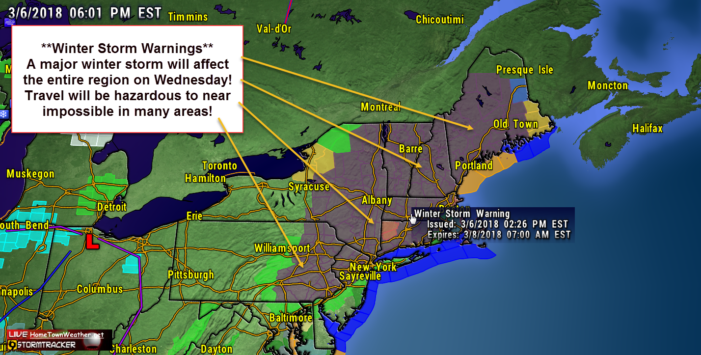
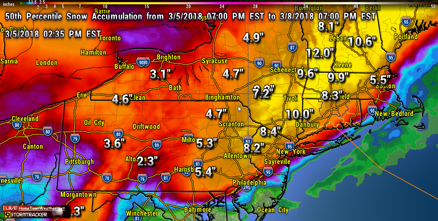
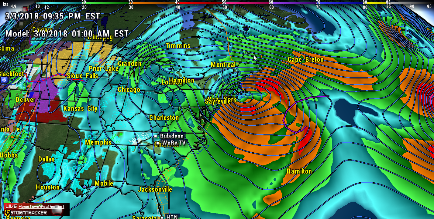
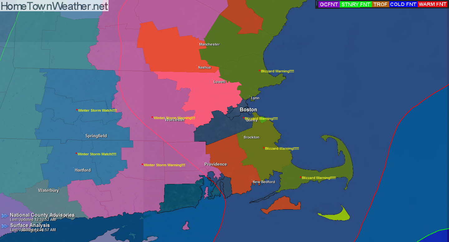
Another week, another Nor’Easter. It is starting to be a weekly routine in the Mid Atlantic and New England. A surface low will develop off the Delmarva Peninsula tonight and will drift northward as it develops. There is more confidence that the track will be closer to the coast and the result will be more precipitation, mostly in the form of snow. As a result, Winter Storm Warnings have been issued for a good part of the region.

Another Nor’Easter Threatens the North East

With the threat increasing for another Nor’Easter this Wednesday and Thursday in New England, folks should be getting ready for another round of power outages. In some cases, there are still people that have not got their power back from the last storm. it is possible that some part of the North East could have blizzard warnings. The following snow model shows some decent plowable snow coming to most areas.

Second Round of Storms Possible for North East!

As if the latest super storm was not enough, yet another round of potential severe weather is possible about mid week in the north east. Models are again suggesting a developing low pressure area moving up the coast and creating a wind, coastal flood and snow event.

Although not near as bad, it will be affecting many of the same areas that were just hit hard by Riley. In many cases, recovery is only beginning.

Potential New Years Eve Storm Possible

Many parts of the North East have been treated to a White Christmas this year but what about New Years? There remains the potential for a Nor’Easter to form off or on the East Coast this New Years Eve but a couple of things will have to happen in order for this scenario to take place.

The GFS shows the center of the system offshore but this could change and a storm could track either closer to the coast or farther offshore.

Blizzard Warning Update….

***Blizzard Warning update**** Eastern Massachusetts

Hazard Types: Blizzard conditions including heavy snow, poor visibility and strong damaging winds

Accumulations of 10 to 14 inches.

Timing: Saturday night into Sunday…

Travel will become nearly impossible and potentially life threatening!

White out conditions are possible with winds 30-40 MPH with gusts to 75.

Temperatures will be around 20 degrees.

Massachusetts Radar and Forecast:
http://www.massachusettsradar.com/

New York/New Jersey Forecast and Radar:
http://www.joesdiscoweathercentral.com/New_York_and_Vicinit…


warnings

More Snow For New England?

The answer to the title question is yes. More snow is on the way to New England. A low pressure will form south of New England late tonight and intensify offshore. This will bring light snow to the region. The winds will create dangerous wind chills tonight.

The bigger story will be this coming weekend. There is a potential for another strong coastal storm. Blizzard conditions are possible for the coastal New England. Then, some of the coldest air of the season will overspread the area. Yet another storm is forecast by midweek. These are the three lows that I pointed out in an earlier post on Facebook.

Winter Storm Watch for New York/New Jersey

Winter Storm Watch for New York/New Jersey area.

URGENT – WINTER WEATHER MESSAGE
NATIONAL WEATHER SERVICE MOUNT HOLLY NJ
358 PM EST SAT JAN 31 2015

…A SIGNIFICANT WINTER STORM IS POSSIBLE FROM LATE SUNDAY INTO
MONDAY…
NJZ012-PAZ101-011000-
/O.EXA.KPHI.WS.A.0002.150202T0000Z-150202T1800Z/
MIDDLESEX-WESTERN CHESTER-
INCLUDING THE CITIES OF…NEW BRUNSWICK…HONEY BROOK…OXFORD
358 PM EST SAT JAN 31 2015

…WINTER STORM WATCH IN EFFECT FROM SUNDAY EVENING THROUGH
MONDAY AFTERNOON…

THE NATIONAL WEATHER SERVICE IN MOUNT HOLLY HAS ISSUED A WINTER
STORM WATCH. IT IS IN EFFECT FROM SUNDAY EVENING THROUGH MONDAY
AFTERNOON.

Another Major Winter Storm for New England

**Major Winter Storm Expected for New England late Sunday through Monday****
****Heavy Snow….8 to 14 inches****

As you can see in the precipitation graphic, areas to the south including New Jersey and New York will likely start out as snow but then a mix will later develop. New England should see all snow.

The Snow Depth graphic from the GFS model gives an idea what to expect in the way of snow accumulations.

NATIONAL WEATHER SERVICE TAUNTON MA
323 PM EST SAT JAN 31 2015

Coastal Flood Warnings for Coastal Massachusetts

COASTAL HAZARD MESSAGE
NATIONAL WEATHER SERVICE TAUNTON MA
203 PM EST TUE JAN 27 2015

…MODERATE TO MAJOR COASTAL FLOODING NORTH AND EAST FACING
SHORELINES OF CAPE COD AND NANTUCKET AND GENERALLY MODERATE
ELSEWHERE ALONG THE MASSACHUSETTS EAST COAST FOR THE LATE
AFTERNOON HIGH TIDE…

MAZ007-015-016-019-022-024-280100-
/O.CON.KBOX.CF.W.0002.000000T0000Z-150128T0100Z/
EASTERN ESSEX MA-SUFFOLK MA-EASTERN NORFOLK MA-
EASTERN PLYMOUTH MA-BARNSTABLE MA-NANTUCKET MA-
203 PM EST TUE JAN 27 2015

…COASTAL FLOOD WARNING REMAINS IN EFFECT UNTIL 8 PM EST THIS
EVENING…

* LOCATION…THE EASTERN MASSACHUSETTS COAST INCLUDING CAPE COD
AND NANTUCKET.

Potential Snow For New England | March 25, 2014

Good morning everybody. The storm that is expected to impact the North East will offer a glancing blow to most locations from New Jersey through New England. In the latest report, 2 to 4 inches of snow are expected except the far eastern parts of the Cape where blizzard conditions are still possible.

On the current forecast track, areas such as Boston will only see nuisance snow and not an all out blizzard.

Your Source for Treasure Coast, Florida Forecasts and Radar!Treasure Coast Forecast