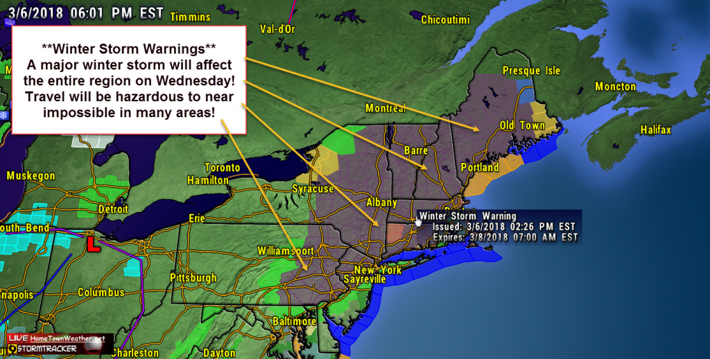
Another week, another Nor’Easter. It is starting to be a weekly routine in the Mid Atlantic and New England. A surface low will develop off the Delmarva Peninsula tonight and will drift northward as it develops. There is more confidence that the track will be closer to the coast and the result will be more precipitation, mostly in the form of snow. As a result, Winter Storm Warnings have been issued for a good part of the region.
Tag Archive for new england
Snow Probability Charts for Days 1, 2 and 3
We just ran the Day 1, Day 2 and Day 3 snow probability chart. The areas in RED have the greatest chances for significant snowfall greater then 4 inches.
http://www.joesdiscoweathercentral.com/Weather_Models.html
More Snow For New England?
The answer to the title question is yes. More snow is on the way to New England. A low pressure will form south of New England late tonight and intensify offshore. This will bring light snow to the region. The winds will create dangerous wind chills tonight.
The bigger story will be this coming weekend. There is a potential for another strong coastal storm. Blizzard conditions are possible for the coastal New England. Then, some of the coldest air of the season will overspread the area. Yet another storm is forecast by midweek. These are the three lows that I pointed out in an earlier post on Facebook.
Another Major Winter Storm for New England
**Major Winter Storm Expected for New England late Sunday through Monday****
****Heavy Snow….8 to 14 inches****
As you can see in the precipitation graphic, areas to the south including New Jersey and New York will likely start out as snow but then a mix will later develop. New England should see all snow.
The Snow Depth graphic from the GFS model gives an idea what to expect in the way of snow accumulations.
NATIONAL WEATHER SERVICE TAUNTON MA
323 PM EST SAT JAN 31 2015
Coastal Flood Warnings for Coastal Massachusetts
COASTAL HAZARD MESSAGE
NATIONAL WEATHER SERVICE TAUNTON MA
203 PM EST TUE JAN 27 2015
…MODERATE TO MAJOR COASTAL FLOODING NORTH AND EAST FACING
SHORELINES OF CAPE COD AND NANTUCKET AND GENERALLY MODERATE
ELSEWHERE ALONG THE MASSACHUSETTS EAST COAST FOR THE LATE
AFTERNOON HIGH TIDE…
MAZ007-015-016-019-022-024-280100-
/O.CON.KBOX.CF.W.0002.000000T0000Z-150128T0100Z/
EASTERN ESSEX MA-SUFFOLK MA-EASTERN NORFOLK MA-
EASTERN PLYMOUTH MA-BARNSTABLE MA-NANTUCKET MA-
203 PM EST TUE JAN 27 2015
…COASTAL FLOOD WARNING REMAINS IN EFFECT UNTIL 8 PM EST THIS
EVENING…
* LOCATION…THE EASTERN MASSACHUSETTS COAST INCLUDING CAPE COD
AND NANTUCKET.
Mid Atlantic Readies For Major Winter Storm
Winter storm watches and warnings are in place for much of the Eastern US tonight as a major winter storm promises to create havoc. This system could be extremely disruptive for both commuters and travelers Flights are already cancelled going into Atlanta, which is a major hub for travelers.
The system will be bringing a combination of ingredients including ice and sleet in the south to heavy wet snow in the north east.
Significant Snowfall Possible In Southern New England
A significant snowfall event is possible across much of Southern New England as a low pressure area tracks between Nantucket and the 40N/70W location. In addition, another snow event is possible over the weekend.
Overall, there is significant confidence that a winter storm will impact the souther New England area. The expected impact will be late Tuesday night through Wednesday.
There is some uncertainty with snowfall totals as the models tend to shift back and forth in regard to the air temperatures. This can make a significant difference either way in the snow totals.
Major Winter Storm Headed To New England Tuesday
A robust winter storm may be in store for Massachusetts early this week. I know it is almost spring but the cold air and winter weather just does not want to stop! A very anomalous air pattern is beginning to unfold and may obtain unprecedented values. What this means is a southern drop of the polar jet across the Continental US. This will help support a major snow event in New England. The models differ some on exactly what areas will get the most snow but it looks like the region around the Mass Pike will likely see the most snow. Other areas could see high accumulations as well if the changeover to rain is later or does not happen at all.


