
Hurricane season is still almost 3 months away but we Storm Spotters are already looking ahead at the 2017 season. This year there will be some changes to the products that are delivered by the NHC. This year the storm surge maps that have been experimental will go live. This tool will be a lifesaver for sure. It will give you up to the minute information of what areas will be affected by deadly storm surge. Remember that most hurricane deaths are not caused by winds but rather from drowning in waters created by the hurricanes storm surge.
Tag Archive for Tropical Storm
Hurricane Season 2016 Winding Up
Hurricane season 2016 is beginning to wind up and the parade of storms is starting to line up across the toasty Atlantic. It is so hard to ponder that it has been 11 years since we have a hurricane make landfall along the US East Coast. This is without doubt one of the longest hurricane draughts we have seen in recent history. The big question is if it will continue through 2016.
Category: Invest 96 and 97, Tropic Watch 2016 |
Tags: hurricane, invest 96, Invest 97, Tropical Storm
Hurricane Season 2016 Begins Today
Good Morning everybody and welcome to hurricane season 2016!! Today marks the first day of the Atlantic hurricane season. This year we area starting off the season with 2 storms already under our belt. In fact, some global models are showing the potential to a tropical entity early next week. I would not bank a whole lot on the hype since right now the Gulf of Mexico is completely clear and a forecast that far out is simply way too much speculation.
Hurricane Watches For The Central Bahamas..Joaquin Strengthens
Good evening everybody. AS of 11 PM**** Hurricane Watches have been issued for the Central Bahamas******
Maximum sustained winds are now 70 MPH and Joaquin is expected to be a hurricane tonight.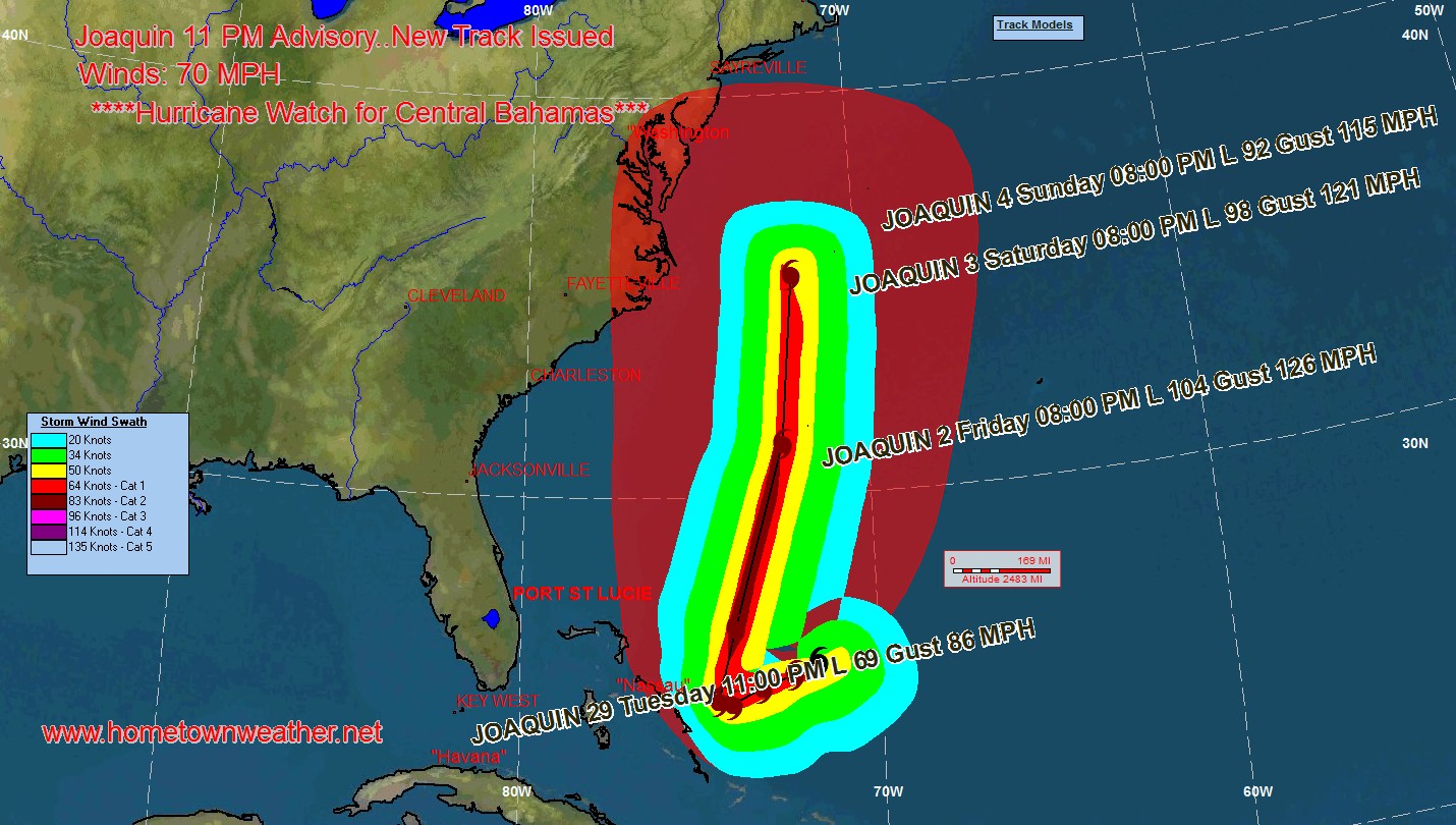
The cloud pattern of Joaquin continues to get better organized and the outflow is becoming much more pronounced. The cyclone is over very warm water and in an increasingly favorable environment. Many of the models are showing significant strengthening and the NHC forecast for intensity could be very conservative.
Joaquin Gets A Little Stronger
Good afternoon everybody. We have a very interesting scenario unfolding as Joaquin continues to baffle the experts. The system is still moving West and at least one of the major models has it reaching the Bahamas before turning north. The shear that has been holding the system back is gradually going to weaken allowing intensification of the cyclone. Once past the Bahamas the models are mixed from a landfall near Virginia as a major storm all the way to a recurve out to sea. Until the system gets caught up in a steering current the models are going to be only a minimal guide.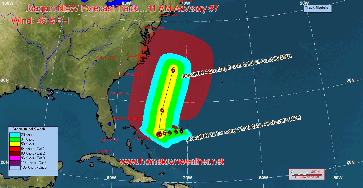
Tropical Storm Joaquin Forms
***Now Tracking Tropical Storm Joaquin****
Depression 11 has strengthened to Tropical Storm Joaquin sooner then expected. Winds are now at 40 MPH with a cetral pressure of 1002 MB.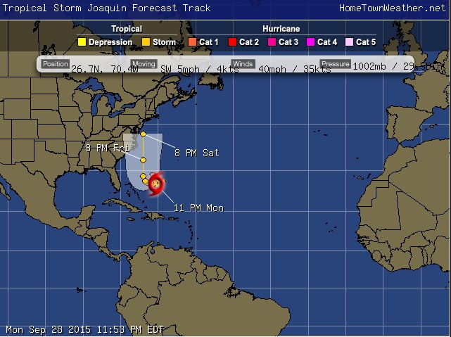
Satellite has shown that the cloud pattern has thunderstorm activity has increased and has gotten better organized over the past few hours.
The system is actually moving towards the southwest. The movement should then begin towards the west. This westward movement will likely continue for a couple of days. The system is being blocked by an upper level ridge.
Colorado State Predicts A Below Normal Hurricane Season
The next agency and probably the most famous, William Grey of the Colorado State University, has released their predictions for the 2014 Atlantic Hurricane Season. A few days ago we released the prediction of Weather Bell.
As with Weather Bell, Colorado State is predicting a below average hurricane season. They are predicting 9 total storms with three becoming Hurricanes and only one becoming major with winds exceeding category 3 strength. This is an amazing low prediction given the trend that was happening in the Atlantic just a couple of years ago.
Category: Tropic Watch 2014 |
Tags: El Nino, emergency warnings, hurricane, outlook, Phil Klotzbach, Philip Klotzbach, prediction, saffir-simpson, Tropical Storm, William Gray -