
Good morning everybody. Joaquin continues to batter the Central Bahamas with category 4 winds of 130 mph. The cyclone is now undergoing an eyewall replacement cycle. The system is now finally beginning the turn and is moving towards the North West very slowly. The wind field has expanded and it is affecting areas all the way to Cuba and parts of the Dominican Republic.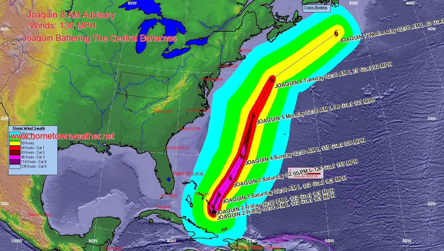
Archive for Joaquin
Joaquin Still Battering The Bahamas
00Z New GFS Model Run | Shifted West
The new hot off the press 00Z American Model has shifted west from the previous runs. We will have to watch and see if this trend continues. This is why you still need to be vigilant till this system is finally out of here.
Joaquin Now Category 4 Storm!!
***Joaquin Now A Category 4 Hurricane of 130 MPH. The Bahamas are now getting hit hard.*****Pressure continues to fall 936 MB*******This is an intense major hurricane!!********
A Hurricane Warning is in effect for…
* Central Bahamas
* Northwestern Bahamas including the Abacos, Berry Islands,
Eleuthera, Grand Bahama Island, and New Providence
* The Acklins, Crooked Island, and Mayaguana in the southeastern
Bahamas
A Hurricane Watch is in effect for…
* Bimini
* Andros Island
New GFS Model Keeps Joaquin Offshore
The new GFS model is more in line with what the Euro has been saying for days. It is keeping the cyclone well offshore the US coast. The big question is if this new model data will affect the new track at 2. We will have to see. The model trends seem to be tracking towards the east. These models might shift back and forth even more before an exact track is determined.
There are no watches or warnings for the US at this time. Meanwhile, the Bahamas are getting pounded with a 125 MPH hurricane on their doorstep.
Hurricane Joaquin Now A Category 3 Hurricane!!
***Please note this a long post but contains a lot of important information***We are a bit late but it takes time to review all the information and models.
Joaquin Is Now a MAJOR hurricane with sustained winds of 115 MPH**** The Bahamas are getting battered and will continue to do so tonight. The minimum central pressure is now 951 MB.***
A dangerous storm surge of 5 to 8 feet is possible in the Bahamas tonight. 5 to 10 inches of rain are possible in the path of this storm. Swells will begin to affect portions of the SE coast of the United States.
The Latest GFS Model Animation of Joaquin
The latest (18Z) model animation of Joaquin is quiote consistent with most of the model runs as well as the forecast track. Watches and warnings will likely be needed for some part of the East Coast Thursday night.
..
The latest GFS Model | Joaquin Threatens US East Coast
The latest GFS model still wants to insist on a major hurricane approaching the Mid Atlantic States. Although this is only one scenario most of the other models are following suit as well. An exact location for an impact will be determined by how far south and west the cyclone goes before being dragged to the north by the trough.
Joaquin Becomes A Hurricane
***Joaquin Becomes A Hurricane****
A Hurricane Warning is in effect for…
* Central Bahamas including Cat Island, the Exumas, Long Island,
Rum Cay, and San Salvador.
A Hurricane Watch is in effect for…
* Northwestern Bahamas including the Abacos, Berry Islands, Bimini,
Eleuthera, Grand Bahama Island, and New Providence, but excluding
Andros Island
Winds have increased to 75 MPH and the central pressure has dropped to 971 MB.
Latest GFS Model Run of Joaquin
The latest GFS model run shows Joaquin making a hook into the Eastern US as a major hurricane.
Hurricane Watches For The Central Bahamas..Joaquin Strengthens
Good evening everybody. AS of 11 PM**** Hurricane Watches have been issued for the Central Bahamas******
Maximum sustained winds are now 70 MPH and Joaquin is expected to be a hurricane tonight.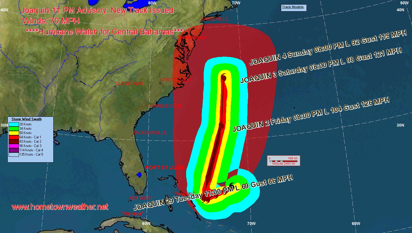
The cloud pattern of Joaquin continues to get better organized and the outflow is becoming much more pronounced. The cyclone is over very warm water and in an increasingly favorable environment. Many of the models are showing significant strengthening and the NHC forecast for intensity could be very conservative.