
***Now Tracking Tropical Storm Joaquin****
Depression 11 has strengthened to Tropical Storm Joaquin sooner then expected. Winds are now at 40 MPH with a cetral pressure of 1002 MB.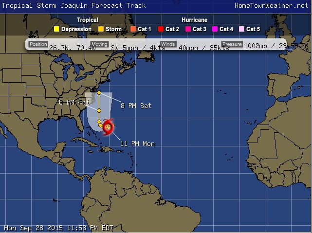
Satellite has shown that the cloud pattern has thunderstorm activity has increased and has gotten better organized over the past few hours.
The system is actually moving towards the southwest. The movement should then begin towards the west. This westward movement will likely continue for a couple of days. The system is being blocked by an upper level ridge.
Later in the forecast period, a trough is expected to amplify over the Eastern United States. This should cause the cyclone to accelerate to the north towards the Mid Atlantic as a tropical storm. The new track has been adjusted to account for the west and southerly drift. More adjustments to the west could be needed before a final track is determined.
Folks in the Mid Atlantic, especially New York and New Jersey , need to watch this system carefully. #flwx#njwx#nywx#joaquin
Tropical Models and Forecast Track:
http://www.joesdiscoweathercentral.com/Model1.html
Tropical Updates Fresh and Up To Date:
http://www.joesdiscoweathercentral.com/Tropical_Web_Forecas…
Atlantic Tropical Outlook and Storm Details:
http://www.joesdiscoweathercentral.com/Tropical_Outlook.html
Full Coverage from Hurricane Central:
http://www.joesdiscoweathercentral.com/Joe_s_Disco_Hurrican…

