Archive for Tropic Watch 2012

Super Storm Sandy One Year Later

One year ago today, a hybrid storm called Super Storm Sandy hit the North East with high winds and an extreme storm surge. Usually when a nor’ easter or hurricane hits this area it stays just offshore or makes landfall in Long Island and moves north or north east.

Super Storm Sandy


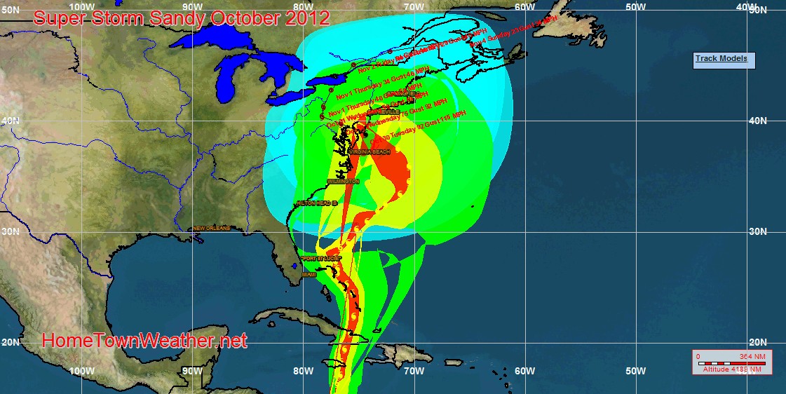
With Sandy, this did not happen. A blocking high pressure area to the north and east of the region blocked the system and forced it to do the unthinkable and head right into the Jersey coast.

Super Storm Sandy Slammed The North East One Year Ago Today

One year ago today, Super Storm Sandy devastated the East Coast of New Jersey and severely flooded the New York City area. Today, there are no tropical systems being monitored in the Caribbean but the clean up and rebuilding still continue in many parts of the North east.

Invest 97 Remains Disorganized

Happy Labor Day Everybody!! I hope you enjoy the final day of the summer vacation season.

Invest 97 has remained the same overnight. Dry air in the middle atmosphere is keeping her in check at the moment. The movement over the next few days will be slow as will any development. As the system passes the Lesser Antilles, conditions appear to be more conductive for tropical development. We will have to just wait and see if this system will defy the hostility that appears to be hindering most tropical cyclone activity thus far this year.

Labor Day 2013 Will Be Hurricane Free

As we head into the final official end of the summer vacation season, things are quiet in the tropics. There are two areas we are watching but the most vigorous area is in the far eastern Atlantic and even if formation occurs, it will most likely stay at sea and never affect land. This is one Labor Day where the threat for a  hurricane will not be a factor.

Hurricane Sandy-An After Thought

Hurricane Sandy will be one of the most talked about storms for years as it massively damaged a good portion of the famous Jersey shore. In addition, massive damage is also evident in New York along with inland areas as well. I am a native of New Jersey and I was born and raised in that state. I can remember many times over the years where water would come over the barriers and dunes during severe storms and it would cause flooding in many cases. What happened here this month was totally different from anything that has happened here before. I even remember a few times when the pier at Seaside had to be repaired due to storm damage. Back in the early days of the boardwalk, I can remember several times when fire destroyed parts of the boardwalk in Point Pleasant. That was when they used the old boards that were soaked in a preservative that had a distinctive smell when you walked along the boardwalk. Improvements in materials over the years have the boardwalks burning a bit less likely but nothing can stop the power of a major storm surge, nothing.

Hurricane Sandy Officially Made Landfall at Atlantic City New Jersey

Hurricane Sandy officially made landfall at Atlantic City. The system made a jog to the north just before landfall and hit with the lowest pressure ever recorded in Atlantic City.  The pressure at landfall was a staggering 946mb.

Here is the last official hurricane statement from the NHC since Sandy is now post tropical.

POST-TROPICAL CYCLONE SANDY DISCUSSION NUMBER  31
NWS NATIONAL HURRICANE CENTER MIAMI FL       AL182012
1100 PM EDT MON OCT 29 2012

Hurricane Sandy Slams Into The East Coast

Hurricane Sandy, now post-tropical storm Sandy, has slammed into the East Coast of the US. The Water rise at Battery Park in New York is a staggering 14.8 feet. Water is rushing into subway stations and the reports that Wall Street trading floor was flooded we found was not true. The Daily News is also under water. There are also reports of water getting into the Brooklyn Battery  Tunnel.

Sandy To Make Landfall at 6 PM in Southern New Jersey

Hurricane Sandy is expected to make landfall near Cape May NJ at around 6 PM tonight. Winds remain at 90 MPH as the system races towards the coast.

Massive storm surge and wind will cause severe flooding and damage along the entire Jersey Shore.

Do not venture from your safe space. Stay in place until the storm passes.

Hurricane Sandy Ready To Strike

Hurricane Sandy has parts of Atlantic City under water. Parts of the boardwalk are floating in the water. In addition, 35 miles of the Garden State Parkway is closed due to flooding. There is not much that can be said but the extreme threat is imminent. Sandy is coming ashore in about 3 to 4 hours and the high tide tonight is going to be tremendous for storm surge. Hunker down and be safe. It is too late to move if you have not done so already.

Severe Flooding in Atlantic City

I have received reports that parts of the Atlantic City boardwalk were floating in the flood waters. This is likely near the location where the storm will come ashore tonight.  People  are trapped by high water and rescues will be attempted when this tide cycle recedes. Tonights high tide will be the highest of the storm.

There are people who cannot be rescued at this time.

Police are not responding to many calls because of the severe flooding.

Your Source for Treasure Coast, Florida Forecasts and Radar!Treasure Coast Forecast