
Eleven years ago today, our day started out as a normal day at our Stuart K Mart. Although we were all aware of a distant hurricane that was forecast to brush by Tampa in about a week, nobody gave it much thought. This thinking was especially true not only for us but for the folks along the west Coast of Florida and especially for people who lived inland from Arcadia to Orlando. All the forecasts were calling for Tampa to be the most likely target. I should note that most of West Coast Florida was in the cone but in 2004,but nobody paid much attention to the cone of error. Most of the forecasts were based on the exact track. That all changed after Charley! In fact, the NHC has seriously considered taking away the track and only issuing the cone to force people to rethink how they track hurricanes. That never happened but forecasters now make it a point to remind people in the cone to be prepared.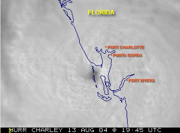
I remember seeing on our TV’s that Charley made a jog to the right and was steaming towards the Florida West Coast head on. Many were caught off guard, as they were not paying a lot of attention to the storm since Tampa kept coming up in the forecasts. Since Charley was such a small compact storm. He kept all the damage confined to areas near the eye wall of the storm. In fact here in Port St Lucie, I do not remember much in the way of severe weather at all. We carefully followed the track of Charley here at our weather station and reported regular updates on our website. We did not have the social networking ability that we have today.
Charley was a category 4 storm that became an inland hurricane, something many folk’s thoughts they were immune from. Many areas near where Charley came ashore were destroyed. One of the hardest hit areas was Arcadia. It was just the beginning of what was to be the most historic hurricane season in the history of Florida. Little did we know?
Also during that same week, Bonnie hit the Panhandle of Florida, which made it the first time that 2 hurricanes hit Florida within a 24-hour period. The peak winds of Charley topped 150 MPH, which would make the storm a strong category 4 hurricane at landfall. Charley was the strongest hurricane to hit Florida since Andrew in 1992. When Charley hit parts of Orlando, winds were still racing at 106 MPH.
We all learned a valuable lessen that day. People began to see the importance of not just looking at the forecast track but to focus on the cone instead. If you are in the cone of error, you should prepare as if the system is on your doorstep. Hurricanes often do and will do sudden unexpected turns without any notice.
http://www.joesdiscoweathercentral.com/
