Archive for May 25, 2021

Monthly Graph of The ENSO From 2020 and 2021

This is a monthly graph of the ENSO from 2020 through 2021. Negative is trending towards El Nino and Positive is trending towards La Nina. Near 0 means Neutral. that is right where we are right now. You can clearly see the positive trend during the peak of the hurricane season last year (La Nina). Right now we are near neutral and the new models expect us to stay that way through the peak of hurricane season. Still points to an active season, but nothing like last year.

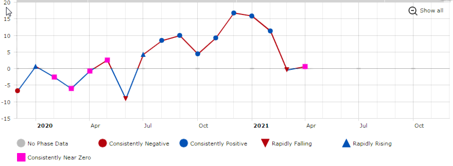
The SOI (Southern Oscillation Index ) is a huge barometer as to how busy a hurricane season might be. Essentially, this is how warm or cold the Pacific waters are in the tropical ENSO regions. The SOI is calculated from the difference in pressure between Darwin and Tahiti. These pressure differences control what direction the trade winds blow in the tropical Pacific. The direction of these trade winds help determine how warm or cold those waters will be.
Like

Comment

NOAA Predicts Above Average Season for 2021

NOAA has released their 2021 Hurricane forecast for 2021. They are predicting 13 to 20 named storms with 6 to 10 becomming Hurricanes and 3 to 5 becomming major hurricanes of category 3 or higher.

Although the 2021 hurricane season is NOT expected to be as bad as the 2020 season, it is expected to be above normal. There was a lot of talk about what areas the hurricanes could hit, it was plainly noted that impact areas cannot be predicted until a storm is about a week out. Early predictions of impact areas is simply not accurate. NOAA has also stated that they have new technologies that they will be using this season such as drones that will be released into the storms and on the ocean surface for a better understanding of what is going on inside the storm. This information will be put into the models to allow for more accurate forecasts.

Non-Tropical Disturbance Has 90% Chance Of Development. No Threat.

Good Thursday morning everybody! The low pressure area in the Central Atlantic now has a 90% chance of development. It will not pose a threat to the United States.

Invest Has 60% Chance Of Development

Even though this area has a 60% chance of formation, It will not affect the US. This is just a simple reminder that the season is almost upon us. We will be here for you without the HYPE and ANXIETY and just the facts as we have been for the past 24 years. Our website was one of the first third party websites in existence in the day. Today, most people either use apps or Facebook for getting their information. Our website is still there although a bit smaller, for those that still get their information on a computer. For fastest updates, Facebook is the way to go. We hope everybody fares well this Hurricane Season. Remember that preparation is key.
We do supply models out to about 7 days for those that like to view them. Remember that models are not forecasts and they can and likely will change. They are an important part of looking into the future. Models out past 7 days are quite useless and we rarely will show them.
We will hope and pray that the 2021 Hurricane Season spares as many as possible the extreme damage that we have seen over the years. Simply be prepared and ready for the worst and hope for the best.
Your Source for Treasure Coast, Florida Forecasts and Radar!Treasure Coast Forecast