
Not a day goes by where somebody in Florida or the Islands of the Caribbean remembers the day Hurricane Irma paid a visit in September of 2017. In that year, all the signs of an extreme hurricane season where there. SST temperatures were at their highest, the wind shear in the Atlantic and Caribbean was low and the Bermuda high was in the perfect position for a US landfall. All the ingredients were in place.
Tag Archive for tropical outlook
Potential Tropical Activity for Florida
Good evening everybody. We continue to closely monitor the potential development in the Gulf. System development is becoming more likely as time goes on. Regardless of system development, rain chances are going to increase significantly early next week in East Central Florida. Deep tropical moisture is going to bring increased rain chances to our region as well as most of Florida.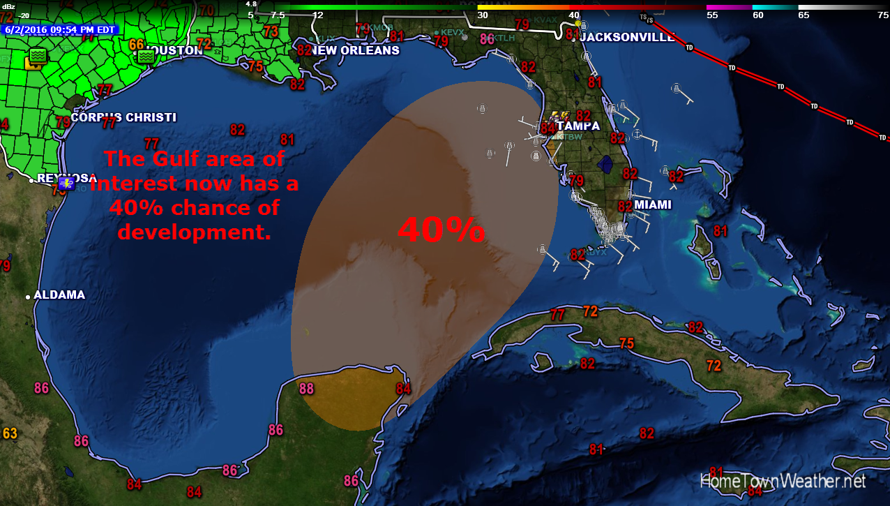
Tropical Storm Erika Could Pose A Florida Threat
***Tropical Storm Erika Could Pose A Significant Threat For Florida Or Another SE Coast Location*****
Erika is still a tropical storm but global models and the official track are telling the story. For the first time in many years (and an El Nino year I might add) Florida could be under the gun.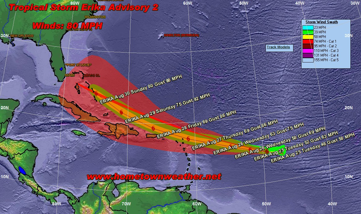
The primary steering current is being provided by the subtropical ridge to the north of Erika. This is keeping her on a primarily westward motion.
Tropical Storm Erika Forms in Atlantic
***Tropical Storm Erika Forms In Atlantic****
Good evening everybody. Unlike Danny, Tropical Storm Erika is likely going to keep more momentum as the cyclone travels through the Atlantic and Caribbean at a pretty good clip. Erika is forecast to steadily increase over at least the next 48 hours. Later in the 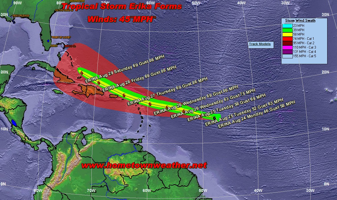 forecast period, Erika will likely weaken to some degree as she encounters an increase in vertical shear. Since this storm is larger then Danny, it will take a little more of a beating before giving in.
Tropical Storm Danny 8 AM Update
Good morning all!! This Wednesday morning we are tracking Tropical Storm Danny. Danny has changed little since last night with winds still at 50 MPH. The models are in excellent  agreement on the future track. The good news is that most of the models are indicating that Danny will fall apart or weaken in the Caribbean. This would be good news for folks on the mainland US if this does indeed happen.
The system is something that needs to be watched, especially given the forward direction the models are taking it. The track has been shifted slightly north from previous forecasts.
Tropical Storm Danny Forms in Atlantic
*****We now Have Tropical Storm Danny******
Tropical Storm Danny is 1595 miles from the Windward Islands. Maximum sustained winds are now 40 MPH with a central pressure of 1008  MB.
MB.
The cloud pattern continues to improve with an outflow pattern beginning to develop. Danny will continue west-northwest into a weakness of the subtropical ridge. After 72 hours, the ridge will build back in and then a more westerly motion will take place. How soon this happens will determine where Danny may be in relation to the Windward Islands in about a week.
Category: Danny |
Tags: danny, track of danny, tropical models, tropical outlook, tropical storm danny
El Nino Could Be Strongest Ever
Good morning everybody. The tropics remain quiet although there is chatter about something forming from the tail end of a stalled frontal system later this week off the SE coast of the US. This potential system could drag moisture our way in Florida over the weekend. We will carefully watch to see if anything actually develops.
Tropical Storm Gonzalo Gaining Steam…No Mainland US Threat
Good morning all. Tropical Storm Gonzalo continues to intensify and a Hurricane Warning has been posted for the British Virgin Islands.
An Air Force Reserve reconnaissance aircraft investigating Gonzalo
this morning found 850 mb maximum flight-level winds of 64 kt along
with reliable SFMR surface winds near 55 kt in the northeastern
quadrant, plus a central pressure of 992 mb. In addition, the
Antigua-Barbuda Meteorological Service recently reported a sustained
wind of 58 kt and a gust to 76 kt. Based on these data, the
intensity has been increased to 55 kt. Reports from the aircraft
radar and Antigua-Barbuda also indicate the center of Gonzalo passed
over Antigua between 1300-1400 UTC.
Category: Gonzalo |
Tags: gonzalo, puerto rico, tropical outlook, tropical storm gonzalo, virgin islands
***Updated Outlook on Invest 92*****
***Updated Tropical Outlook on Invest 92*****
The updated tropical outlook indicates that shower activity associated with a small area of low pressure midway between the Cape Verde Islands and the Lesser Antilles has increased over the past few hours. The area continues to suggest that organization is beginning. Satellite data also indicates that a closed low is forming. Winds near a small area in the center could be near Tropical Storm Force. A tropical depression or storm could form over the next couple of days. Interests in the Lesser Antilles should monitor the progress of Invest 92.
Tropical Models and Forecast Track:
http://www.joesdiscoweathercentral.com/Model1.html
Potential Tropical Activity Next Week for The Southeast
***Tropical Outlook…Potential Tropical Activity Next week***
Good morning everybody here is the latest tropical outlook! Today we are looking at the potential for a tropical low to form off the coast of the South Eastern United States by either late weekend or early next week. This low is being shown in many of the computer models. Development of this system will be possible should it stay over water long enough. The system should drift south or south west.