
Invest 99 was the little engine that couldn’t. From the first day that we started tracking it, it appeared to struggle for survival. That said, a good part of forecasting a tropical systems track is in the computer generated models. These models in the early stages of a system often create a windshield wiper effect where they keep bouncing back and forth between two points. usually, the final result is someplace in between all the runs. A lot of this information is obtained by NOAA planes risking their lives flying into the storms. The information from these planes is invaluable. Even with all the computer models, manual observations, satellites and radar, sometimes systems do what they want and when they want. In the case of 99L, since it was so weak the models had a rough time trying to find a starting point. The two main models the GFS and the Euro were battling it out to see who could win. In almost every run, our own GFS seems to have had the solution all along but it was discounted because nobody thought it made any sense. Most of the other models were saying we were going to get slammed. Forecasters are often put in a position of either alerting the public of a potential threat or saying everything is going to be fine. When the vast majority of models say everything is not going to be fine, you have to listen to the majority.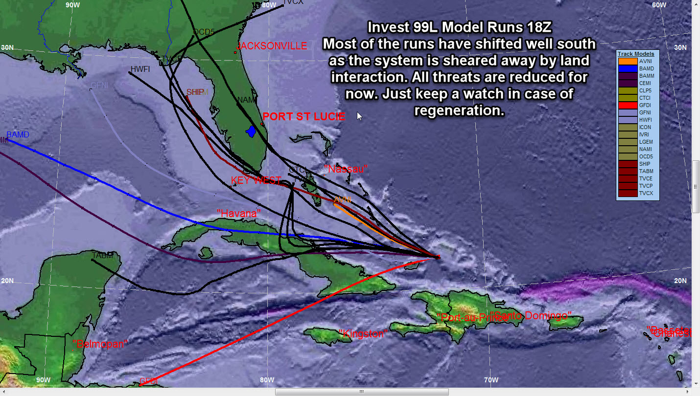
Tag Archive for Invest 99
Invest 99 Was The Storm That Couldn’t
Invest 99 9 AM Update
Invest 99 is getting together and it now has a high chance or 60% chance of development. The models are in good agreement keeping the system in the Caribbean. The first place that has to be ready will be the Windward Islands. The system will most likely remain on the weak side for now after development occurs. Many of the models are taking the system right over the mountainous regions of Hispanola and Cuba. We will have to see if that trend continues. Remember that models get a much better grip on a system after development.We will keep you posted on any developments throughout the day.
Invest 99 Update
Hi everybody. It appears that 99L is getting slowly organized. There is no current low level circulation but water temperatures are high, wind shear is low and the SAL (Saharan Air Layer) is well to the north of the system. If the invest tries to climb north, there is a completely different story. The wind shear is higher and the air is drier as a result of the Saharan Dust. This will help to keep the storm in check should it start to move more to the north.It is still too far out to project a path but it is a real good bet if you live in the Windward Islands that it will be a stormy weekend so watch out for that if you are going on a cruise to that region. Once the system passes the islands it is our turn to be on alert. If the system takes a more northwesterly track towards the US east coast, it will encounter shear which could be a saving grace for the US. Stay posted as things can change quickly. Be ready, be safe. http://www.joesdiscoweathercentral.com/Tropical_Web_Forecasts.html