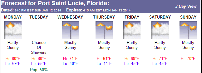
Tonight a high pressure ridge that is centered over the NE Gulf of Mexico is embedded within a deep Westerly flow that will slide it across the deep south and into the West Atlantic tonight. This will produce a dry and stable air mass tonight. Temperatures will generally be in the 50’s overnight in most locations.
Tomorrow, a ridge axis will a short wave trough to develop in the Plains and push into the deep south. The winds will then switch to the South – Southwest and allow the cold front that just passed to return as a warm front. Temperatures will be above average witth highs in the 80’s.
Tuesday, another cold front will move through the region and some showers are possible with the frontal passage but nothing like we saw a few days ago.
The second half of the week will be cool with the coldest night being on Wednesday where some locations could get into the 30’s.
http://www.joesdiscoweathercentral.com/Web_Forecasts.html