Archive for Uncategorized

Heavy Snow Heading Towards the North East Today and Tonight

***The Largest North East Storm Of The Season Poised To Strike Today and Tomorrow****

Heavy snow and extremely low temperatures are coming to the North East today. Areas such as Boston and Long Island along with the Cape in Massachusetts are going to be in the epi-center of the storm. Blizzard warnings are in effect for parts of Long Island and the Cape for strong winds with blowing snow later today and tonight. Snow is already falling from moisture coming off the water in Boston and other coastal areas in Massachusetts.

Uniden To Premier A New Line Of Police Scanners

Uniden has announced a new line of police scanners today! We have been using Uniden scanners for years to bring you the live St. Lucie County police scanner action that we provide. There is no word on exactly what new features will be offered but they are coming out just in time for the holiday season. I know I will be watching, will you?

Police scanners can be very useful during severe weather events alerting to streets that might be flooded, tornado sightings and road closures. They should be a part of your emergency weather kit.

Urban Flood Advisory For Brevard County

THE NATIONAL WEATHER SERVICE IN MELBOURNE HAS ISSUED AN

* URBAN AND SMALL STREAM FLOOD ADVISORY FOR…
EAST CENTRAL BREVARD COUNTY IN FLORIDA…
THIS INCLUDES THE CITIES OF…SATELLITE BEACH…MELBOURNE…
MALABAR…INDIALANTIC…GRANT…

* UNTIL 415 PM EDT.

* AT 314 PM EDT…RADAR WAS DETECTING RAINFALL RATES OF 1 TO 2
INCHES IN LESS THAN ONE HOUR. THE PUBLIC REPORTED VERY HEAVY RAIN
EARLIER IN THE VERO BEACH AREA AND SOUTHERN BREVARD COUNTY BARRIER
ISLAND COMMUNITIES. SOME AREAS REPORTED OVER A FOOT OF WATER IN LOW
LYING AREAS.

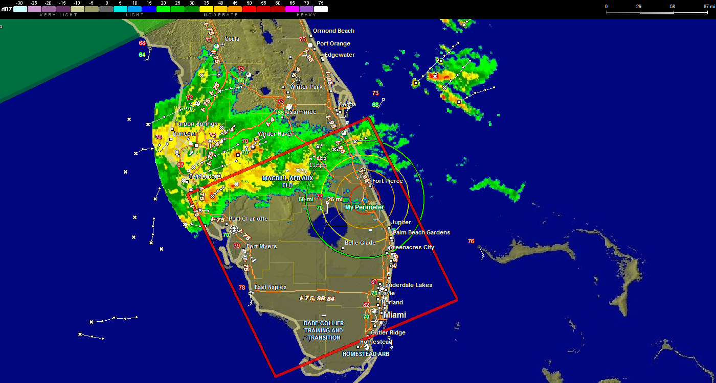
Graphic of Tornado Watch Area in Florida

The area outlined in red is the area affected by today’s tornado watch.

http://www.joesdiscoweathercentral.com/Florida_Doppler_radar.html

Tornado Watch

Blizzard Warnings for Massachusetts and New York

Blizzard warnings have been issued for eastern and SE Massachusetts along with the New York City area. Winter Storm Warnings are in place elsewhere.

Increasing clouds tonight will lead to light snow early tomorrow. The air column will remain cold enough to support snow  throughout  the region.

Snow will become heavy by the evening commute and travel will become hazardous.

Travel later in the night may become impossible. If you need to travel, be at your destination before Friday night as you will not be able to get anywhere after that.

Frigid Temperatures Hitting the Northern Tier of US

Hi everybody, as mentioned in the previous blog post the weather has turned brutally cold in many parts of the country. Some areas in Massachusetts are going down to the single digits and even in the negative numbers this week. in fact areas as far south as Charleston South Carolina are going to feel the cold with temperatures as low as 25 degrees in these areas. For the Sunshine State, we are still looking at nice temperatures but a bit cooler then last week.

Hurricane Season 2012 Comes to An End

Hurricane season 2012 has  finally  come to an end. The season was a strange one with 19 named storms but mainly two that we will remember well. Isaac, if you recall, was the storm that tried but did not do much damage as it moved through the  Florida  Keys. As it moved through the Caribbean and into the Gulf of Mexico, it generated large amounts of rain and flooding, especially along the Treasure Coast of Florida. It then made landfall near New Orleans in almost the same place and date as Katrina. The system caused lots of flooding and some breaches of the dikes. The damage was nothing like that of Katrina but it did create an impact on the Gulf Coast.

Live Atlantic City Information

We are broadcasting live information from Atlantic City, New Jersey today and tonight (as long as the feed is up) so you can get emergency information on what is going on in the city. It is  temporarily   being  broadcast on our NOAA Ft Pierce weather radio  feed  page. http://www.joesdiscoweathercentral.com/Streaming_Video.html

Isaac 11 AM Update

Hi everybody, tropical storm Isaac is still a 40 MPH storm. The satellite appearance of Isaac has improved over the course of the morning but the center core is still disorganized. The system has resumed a westward motion that should continue the next day or so. After that the system will respond to a break in the subtropical ridge around Florida and the Gulf of Mexico. The intensity forecast of this storm will be very tricky since all the ingredients needed for rapid intensification are there, Isaac could develop quickly if the inner core gets established better. With that said and looking at the forecast track bear in mind that the model spread goes from Southeast Florida all the way to Western Cuba. One model has the system coming in north of Ft Lauderdale and exiting at Tampa. We MUST remain prudent and do NOT let the small status of the storm fool you. Today will be a transition period where the new data entered into the models will give us a better idea of the exact track. That will come into play tomorrow. Tomorrow we should have a more definitive area where the system will make landfall. The current track has shifted a bit to the west as an adjustment to the relocated center. If the system travels close to the West Coast of Florida, storm surge will be a major issue.This will also be the case in the Florida Keys. It has been some time since they have had a direct it so heads up in that area for sure unless there is a major change in the forecast track.

Flash Flood Watch For Massachusettes

Here are the latest bulletins from Home Town Weather
WGUS61 KBOX 280754
FFABOX

URGENT – IMMEDIATE BROADCAST REQUESTED
FLOOD WATCH
NATIONAL WEATHER SERVICE TAUNTON MA
354 AM EDT SAT JUL 28 2012

..LOCALIZED FLASH FLOODING POSSIBLE THIS AFTERNOON INTO TONIGHT…

CTZ002-MAZ002-003-008>011-NHZ011-281600-
/O.NEW.KBOX.FF.A.0002.120728T1600Z-120729T0800Z/
/00000.0.ER.000000T0000Z.000000T0000Z.000000T0000Z.OO/
HARTFORD CT-WESTERN FRANKLIN MA-EASTERN FRANKLIN MA-
WESTERN HAMPSHIRE MA-WESTERN HAMPDEN MA-EASTERN HAMPSHIRE MA-
EASTERN HAMPDEN MA-CHESHIRE NH-
INCLUDING THE CITIES OF…HARTFORD…WINDSOR LOCKS…CHARLEMONT…
GREENFIELD…ORANGE…CHESTERFIELD…BLANDFORD…AMHERST…
NORTHAMPTON…SPRINGFIELD…JAFFREY…KEENE
354 AM EDT SAT JUL 28 2012

..FLASH FLOOD WATCH IN EFFECT FROM NOON EDT TODAY THROUGH LATE
TONIGHT…

Your Source for Treasure Coast, Florida Forecasts and Radar!Treasure Coast Forecast