Archive for Tropic Watch 2013

Sub-Tropical Storm Melissa Forms in Atlantic

A late season storm has formed in the Atlantic and it could become a hurricane. The storms name is sub-tropical storm Melissa. Fortunately she will stay right where she belongs and that is in the Atlantic. Melissa will be stirring up the surf especially around Bermuda and the Bahamas but she will pose no threat to any land areas.

Melissa is currently sub-tropical but a full tropical transition is expected. This transition will happen by Tuesday.

Winds are currently 60 MPH with a minimum pressure of 987MB.

The Tropics Still Have Some Life

Late season tropical outlook. I know it is November but the disturbed area of weather in the Caribbean that the models showed us last week has materialized. Although conditions are are not great for development at this time, we will continue to monitor the area for you. Remember that hurricane season lasts till November 30.

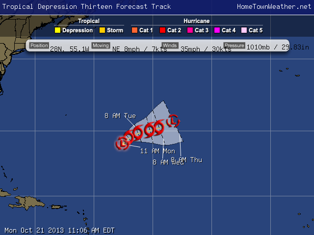
Tropical Depression 13 Forms Near Bermuda

**Tropical Depression 13 Forms Near Bermuda*** There are no coastal watches in effect. The area continues to increase in organization this morning. The system will pose no threat to land and it will be a short lived storm. The system will be whisked out to the north-east and then north until dissipation occurs. There is a potential for some modest intensification over the short term. http://www.joesdiscoweathercentral.com/Tropical_Web_Forecasts.html


Tropical Depression 13

Tropical Storm Karen Friday Morning Update

Some interesting changes in at least one of the models for Tropical Storm Karen this morning. The GFS is showing the cyclone taking a more Easterly track and hitting somewhere around Apalachee Bay and then stalling off the South Carolina Coast. We will have to watch carefully for any signs of this eastward trend as the day progresses.

Mobile Alabama Radar.

In general, Karen is actually a “mess” right now with the effects of the wind shear apparent. The main convection is well east of the center. The central pressure has risen from 999 mb to 1002 mb.

Tropical Storm Karen Remains A Sheared Cyclone

Tropical storm Karen remains a sheared cyclone but is maintaining a very vigorous circulation. Most of the thunderstorm activity is to the north and east of the center. The intensity remains at 65 MPH with some slight strengthening possible before a weakening trend begins before landfall.

According to NOAA aircraft, Karen is moving to the North-Northwest at 9 knots.

Currently, a narrow ridge over Florida is keeping Karen away from the state. This ridge is expected to weaken and allow a more northerly component to Karen. Thereafter, Karen will begin to re curve to the north east.

Tropical Storm Karen Remains Unchanged at 5 PM

Tropical Storm Karen…Hurricane watches in the Panhandle have been changed to Tropical Storm Watches. Hurricane watches are in effect for parts of the Central Gulf.

Karen has not significantly changed this afternoon. She is being plagued by dry air and wind shear. Despite all the negative elements, Karen continues too maintain her intensity. Recon measured an internal pressure of 999MB. The last run still supported maintaining the system as a tropical storm.

Only slight strengthening is expected due to the negative factors and then some weakening is possible as the system comes ashore.

Tropical Storm Karen Forms In Caribbean…Nearing Hurricane Strength

Tropical Storm Karen has formed. A hurricane watch is in effect for the Northern Gulf Coast. There is no threat to East Central Florida. Maximum winds are 65 MPH.

Invest 97 May Be Soon Called Karen

Invest 97 is gaining good banding features and advisories might be issued on this system at any time. It appears that the system will miss or just skirt the Yucatan which will keep it over water. The models are still quite consistent with a track near the Panhandle of Florida. Heavy rain on the outer bands could affect a good part of Florida and increase the rain chances.

Some wind shear is expected to affect the system in the Gulf so that might help to control the development. Interests in the northern Gulf are advised to keep posted on the progress of what will soon be Karen.

Invest 97 May Soon be Karen. Recon To Investigate Today

Good morning everybody, could Invest 97 become Karen?. Invest 97L continues to show signs of more organization this morning. A Recon jet is scheduled to investigate the system today. The models are quite consistent in a weekend landfall along the upper Gulf Coast near the Florida Panhandle.

The system is expected to go over or near the Yucatan and then travel into the Gulf of Mexico. If the system misses land interaction with the Yucatan, this could lead to a stronger storm. It appears there is some strong wind shear near the point of landfall along the Gulf Coast. This may be good news that will limit the strength of the system.

Potential Problems For The Gulf Later This Week

***Tropical Outlook***
Tropical Storm Jerry is meandering aimlessly in the far Atlantic and will pose no threat to land.

Closer to home, Invest 97 has jumped way up in the potential for development overnight. In addition, model runs have changed as well. Most of the models are showing a decent size storm hitting somewhere along the Gulf Coast from the Panhandle of Florida to near Louisiana. I just ran a simulated satellite model over the next week and it shows the system in the Gulf region around Friday or Saturday. Remember that once the system gets better organized, a better handle on the exact track will be evident.

Your Source for Treasure Coast, Florida Forecasts and Radar!Treasure Coast Forecast